|
Bivalvia | Unionoida | Hyrioidea | Hyriidae | Velesunioninae | Alathyria species Alathyria pertexta Iredale, 1934: specimens
7 nominal species as synonyms
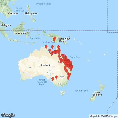
Range: Eastern Australia from Queensland south to New South Wales, and also New Guinea. Map of Georeferenced Specimens
 |
Australia |

ZMB_51037
Richmond River, New South Wales
|

ZMB_MP_0429
Australia
|

ZMB_MP_0432
Queensland
|

ZMB_MP_0427
Sydney
|

ZMB_47539
Queensland, Brisbane
|

BMNH_1964170
Australia
|

ZMB_4712
New Holland
|

SBMHN_141216
Queensland, Australia
|

AMNH_109199
Calliope River, Queensland, Australia
|

AMS_61766
Richmond River, Casino, New South Wales, Australia [-28.867, 153.05 ± 10 km]
|

AMS_62156
Richmond River, Casino, New South Wales, Australia [-28.867, 153.05 ± 10 km]
|

AMS_61854
Upper Brisbane R, beyond Fernvale, Queensland, Australia [-27.45, 152.64 ± 100 km]
|

AMS_61774
Brisbane River, approx 65km from mouth, Queensland, Australia [-27.5, 152.667 ± 10 km]
|

AMS_126247
Saleyard Ck, near Tabulam (In reeds), New South Wales, Australia [-28.883, 152.567 ± 10 km]
|

AMS_83826
Esk, Brisbane River, Queensland, Australia [-27.233, 152.417 ± 10 km]
|

AMS_126045
Mary River, Queensland, Australia [-26.383, 152.75 ± 100 km]
|

AMS_380232
Lake Manchester, Queensland, Australia [-27.483, 152.783 ± 10 km]
|

AMS_62028
Mary River, Queensland, Australia [-26.383, 152.75 ± 100 km]
|

AMS_110211
Barambah Ck, trib of Burnett R, 8km SE. of Gayndah, Queensland, Australia [-26.333, 152.2 ± 10 km]
|

AMS_126102
Dawson R on Rockhampton-Duaringa Rd, Queensland, Australia [-23.788, 149.108 ± 1 km]
|

AMS_126365
Fitzroy R at Duaringa, Queensland, Australia [-23.627, 150.108 ± 100 km]
|

AMS_125929
Blackall, Queensland, Australia [-24.433, 145.467 ± 10 km]
|

AMS_126100
Stradbroke Island, South Queensland; 27°30’S, 153°30’E
|

AMS_61770
Burnett River, Queensland; 25°03’S, 152°05’E
|

AMS_97879
Albert River, near Southport, Queensland ?
|
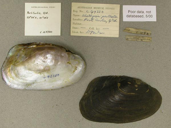
AMS_47330
Port Curtis, Queensland; 23°55’S, 151°23’E
|

AMS_81182B
Brisbane River, 60 mi from Bay, Queensland
|

AMS_61856
Ipswitch, Queensland; 27°37’S, 152°47’E
|

AMS_61769
Queensland, New South Wales Border Dist.
|

AMS_82901
Vandyke Ck, near Springsure, Queensland, Australia [-24.467, 147.833 ± 10 km]
|

AMS_62162
Yeppen Lagoon, Rockhampton, Queensland, Australia [-23.417, 150.5 ± 10 km]
|

AMS_51819
Flinders R, Hughenden, Queensland, Australia [-20.85, 144.2 ± 10 km]
|

AMS_61747
Yeppen, near Rockhampton, Murray Lagoon, Queensland, Australia [-23.417, 150.5 ± 10 km]
|

AMS_62029
Rockhampton (Duckponds), Queensland, Australia [-23.367, 150.533 ± 10 km]
|

AMS_61857
Near Rockhampton, Frogmore Lagoon & duckponds, Queensland, Australia [-23.367, 150.533 ± 10 km]
|

AMS_126044
Yeppen Lagoon, Rockhampton, Queensland, Australia [-23.417, 150.5 ± 10 km]
|

AMS_126220
Raglan Creek at Bruce Hwy, S of Rockhamptom, Queensland, Australia [-23.758, 150.866 ± 1 km]
|
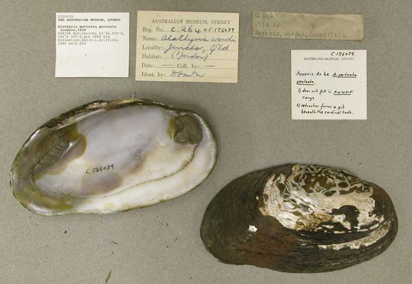
AMS_126039
Jericho, Queensland, Australia [-23.6, 146.133 ± 10 km]
|

AMS_61850
Gladstone, Queensland, Australia [-23.85, 151.267 ± 10 km]
|

AMS_126219
Mary River, Queensland, Australia [-26.383, 152.75 ± 100 km]
|

AMS_126105
Baffle Ck, near Miriam Vale, Queensland, Australia [-24.417, 151.65 ± 10 km]
|

BMNH_MP_090
[no locality available - Australia]
|

AMS_61771
Fitzroy R, at confluence with Alligator Ck, Queensland, Australia [-23.192, 150.408 ± 1 km]
|

AMS_126215
S of Sarina, Lotus Ck, Queensland, Australia [-22.4, 149.167 ± 10 km]
|

AMS_110207
Pioneer R, 25.5km (16mls) W of Mackay (Broad river, rock & sand with weedy pools along edge.), Queensland, Australia [-21.163, 148.858 ± 1 km]
|

AMS_117982
Burdekin R, near Charters Towers (Crawling on sandy river bottom), Queensland, Australia [-20, 146.433 ± 10 km]
|

AMS_381782
Darling Downs, Queensland, Australia [-27.917, 151.75 ± 100 km]
|

AMS_61737
Lagoon, near sandbar across Norman R (near river mouth), Queensland, Australia [-17.567, 140.833 ± 100 km]
|

AMS_144998
Lawn Hill Ck, at Lawn Hill Station (In midden, on river bank), Queensland, Australia [-18.583, 138.583 ± 10 km]
|

AMS_77004
Walkers Ck, 20 miles S of Normanton, on Normanton-Karumba Rd, Queensland, Australia [-17.467, 141.167 ± 10 km]
|

AMS_73049
Walkers Ck, 20 miles S of Normanton, on Normanton-Karumba Rd, Queensland, Australia [-17.467, 141.167 ± 10 km]
|

AMS_61852
Einasleigh River, Queensland, Australia [-18.512, 144.102 ± 100 km]
|

AMS_126040
E Cape York Peninsula, Silver Plains station, Breakfast Creek, Queensland, Australia [-14, 143.508 ± 10 km]
|

AMS_158050
Cape York Peninsula, Palmer R at Palmerville (buried in mud, almost dry waterhole), Queensland, Australia [-16, 144.071 ± 1 km]
|

AMS_385754
Palmer River crossing (Small, flowing side stream, under rocks & on stream bed), Queensland, Australia [-15.997, 144.073 ± 100 m]
|

AMS_392918
Abraham Billabong, Northern Territory, Australia [-14.9, 133.083 ± 10 km]
|

AMS_403003
Arnhem Land, Wilton R, Bulman Waterhole, approx 20km E of "Bulman" Station, Northern Territory, Australia [-13.683, 134.375 ± 1 km]
|

AMS_436283
Muswellbrook, Hunter River, New South Wales, Australia [-32.267, 150.9 ± 10 km]
|

USNM_84416
Moreton Bay, Australia
|

UMMZ_304511
Richmond River, Casino, New South Wales, Australia, -28.86768°, 153.0425°
|

AMS_61749
trib., Einasleigh River, Northern Queensland; 17°34’S-18°20’S, 142°24’E-144°04’E
|

AMS_158036
Lawn Hill NP, near Island Stack, Lawn Hill Ck (Buried in sand, in fast flowing shallow stream), Queensland, Australia [-18.7, 138.483 ± 1 km]
|

AMS_158037
Gulf of Carpentaria, Robinson R Crossing (In sand, in shallow pools), Queensland, Australia [-16.472, 137.047 ± 1 km]
|

UMMZ_304510
Warra Weir Queensland, Australia, -26.92382°, 150.90273°
|

AMS_419947
Calvert River crossing on Carpentaria Hwy (under stone in flowing water and in large pools on surface of Pandanus leaves, under roots, etc.), Northern Territory, Australia [-16.934, 137.361 ± 100 m]
|

UMMZ_22867
Richmond River, Australia
|

AMS_419949
2 km downstream from waterhole behind Lawn Hill Stn homestead (on roots along edges in still side areas), Queensland, Australia [-18.567, 138.586 ± 100 m]
|

BMNH_MP_122
Bogie River, near junction with Burdekin River, North Queensland
|

UMMZ_23083
Australia
|

BMNH_89-10-25-8-9
Richmond River
|

BMNH_89-10-25-24-25`
Richmond River
|

BMNH_86-7-26-332-333
Burnett River, Queensland, Australia
|

BMNH_86-12-3-64
Port Curtis, Queensland
|

BMNH_46-10-7-1-4
Eastern Branch of the Issacs River
|

BMNH_59-10-28-28
Brisbane River, NSW
|

BMNH_MP_139
Burnett River, Gympi
|

BMNH_MP_142
Shoalhaven River, South of Sydney
|

BMNH_MP_138
Australia
|

BMNH_85-6-12-83-84
Isaac and Burnett rivers
|

BMNH_91-11-6-101-102
Port Curtis, Queensland
|

BMNH_91-11-6-100
Burnett River, Queensland
|

DMNH_186525
Victoria, Australia
|

DMNH_172999
Queensland, Australia
|

CM_61.1537
Northeast Australia
|

DMNH_43649
Lotus Creek, 104 mi S Macay, North Queensland, Australia
|

DMNH_51860
Boyne River, Gladstone, Australia
|

DMNH_51862
Boyne River, Gladstone, Australia
|

DMNH_51944
Frogmore Lagoon, Australia
|

DMNH_51946
Lotus Creek, Queensland, Australia
|

AMS_126043
Gayndah, Queensland, Australia 25° 36’ S; 151° 31’ E
|

ZMB_106357
Queensland
|

INHS_85333
Mudgeeraba Creek, S of Nerang, along Springbrook Road, Queensland, Australia
|

MNHN_MP_1455
Lotus Creek, 104 mi SW Mackay, N.Q. Australia
|

AMNH_305977
Lotus Creek, Queensland, Australia
|

MNHN_MP_1540
Nouvelle Hollande
|

MNHN_MP_1483
Rockhampton, Queensland, Australia
|

ANSP_65250
Casino, Richmond River, N.S.W. Australia
|

ANSP_71728
Richmond R., N.S.W.
|

USNM_568974A
Condamine R. Australia
|

USNM_623340
Brisbane R., Wyvenhoe Pocket, Australia
|

USNM_73086
Richmond River, New South Wales, Australia
|

USNM_623347
Maroochy River, Yandina, Queensland, Australia
|

UMMZ_111809
Queensland, Australia
|

UMMZ_111810
Australia
|

UMMZ_111812
Gregory River System, near Plains of Promise, Gulf of Carpentier, Queensland, Australia
|

UMMZ_111816
New South Wales, Australia
|

USNM_84417
New Zealand [probably actually Australia]
|

ANSP_125847
Australia
|

INHS_26300
Lotus Creek, Northern Queensland, Australia
|

ANSP_129956
Rockhampton, Queensland, N. Australia
|

MCZ_201301
Calliope River, near Gladstone, Queensland, Australia
|

MCZ_186735
Burnett River, at Mundubbera, Queensland, Australia
|

MCZ_243497
Dawson River, Moura, 140 mi SW Rockhampton, Queensland, Australia
|

MCZ_196818
Fitzroy River, Rockhampton Basin, Queensland, Australia
|

MCZ_210909
Brisbane River, 40 mi from mouth, Queensland, Australia
|

MCZ_235462
Dawson River, Duaringa, central Queensland, Australia
|

MCZ_191964
tributary of Einasleigh River, northern Queensland, Australia
|

AMS_61765
Richmond River, Casino, New South Wales, Australia [-28.867, 153.05 ± 10 km]
|

AMS_12009
Upper Brisbane River, Queensland, Australia [-27, 152.4 ± 100 km]
|

AMS_61767
Einasleigh River, Queensland, Australia [-18.512, 144.102 ± 100 km]
|

AMS_61703
17 km (10mls) S of Murray-Darling junction, "Mondellin", Victoria, Australia [-34.25, 141.917 ± 10 km]
|

ANSP_232405
Calliope River, Central Queensland, Australia
|

AMS_126271
Murray River
|

AMS_61757
Namoi River, Tarriaro (=Terryarra) bridge, near Narrabri, New South Wales, Australia [-30.396, 149.894 ± 1 km]
|

AMS_61772
Barwon River at Mogil Mogil, New South Wales, Australia [-29.35, 148.683 ± 1 km]
|
|
|
AMS_404108 177.8 km from Marlborough turnoff to inland road, unnamed swampy creek on Sarina - Marlborough Inland Rd (On edges of creek, in mud and on leaves etc.), Queensland, Australia [-21.848, 148.932 ± 100 m]
AMS_346223 2km downstream from waterhole behind Lawn Hill Stn homestead, Queensland, Australia [-18.567, 138.586 ± 100 m]
AMS_126041 Aramac, Queensland, Australia [-22.967, 145.25 ± 10 km]
AMS_327764 Baloona River, S of St George nr Kurary Stn, Queensland, Australia [-28.198, 148.534 ± 100 m]
AMS_125780 Boyne River at Port Curtis, Queensland, Australia [-23.917, 151.383 ± 10 km]
AMS_125776 Brisbane R at Wivenhoe Pocket, Queensland, Australia [-27.433, 152.617 ± 10 km]
AMS_125779 Brisbane River (In mud on river bottom), Queensland, Australia [-27.333, 152.5 ± 100 km]
AMS_107063 Burnett R at Gayndah (Wide, sandy river bed), Queensland, Australia [-25.617, 151.6 ± 10 km]
AMS_422337 Burnett R, at causeway, W of Childers on rd to Booyal (Sandy gravel with stones), Queensland, Australia [-25.229, 152.012 ± 1 km]
AMS_137032 Burnett R, causeway on rd WSW from Booyal, W of Childers, Queensland, Australia [-25.229, 152.012 ± 1 km]
AMS_84520 Callide Ck, Queensland, Australia [-24.367, 150.567 ± 100 km]
AMS_126285 Casino, New South Wales, Australia [-28.867, 153.05 ± 10 km]
AMS_126323 Clermont, Clermont Lagoon, Queensland, Australia [-22.833, 147.633 ± 10 km]
AMS_126101 Comet, Queensland, Australia [-23.6, 148.55 ± 10 km]
AMS_421789 Dawson R at Taroom, Queensland, Australia [-25.643, 149.792 ± 100 m]
AMS_327770 Dawson R at Taroom, Queensland, Australia [-25.645, 149.795 ± 100 m]
AMS_69386 Dawson R near Duaringa, Emerald Rd, Queensland, Australia [-23.792, 149.675 ± 10 km]
AMS_327793 Dawson R nr Theodore on Taroom - Theodore Rd (under rocks and wood), Queensland, Australia [-24.941, 150.07 ± 100 m]
AMS_421792 Dawson R, W of Springsure, off Dawson Hwy, nr Moura Weir, Queensland, Australia [-24.6, 149.91 ± 100 m]
AMS_423041 Dawson R, W of Springsure, off Dawson Hwy, nr Moura Weir, Queensland, Australia [-24.6, 149.91 ± 100 m]
AMS_423042 Dawson R, W of Springsure, off Dawson Hwy, nr Moura Weir, Queensland, Australia [-24.6, 149.91 ± 100 m]
AMS_430721 Duaringa, Queensland, Australia [-23.717, 149.667 ± 10 km]
AMS_126256 Einasleigh, Queensland, Australia [-18.512, 144.102 ± 10 km]
AMS_430738 Einasleigh, Queensland, Australia [-18.512, 144.102 ± 10 km]
AMS_62027 Fitzroy R at Rockhampton (In swamp), Queensland, Australia [-23.333, 150.5 ± 10 km]
AMS_61773 Frogmore Lagoon, Rockhampton (Bottom of dry lagoon), Queensland, Australia [-23.446, 150.539 ± 1 km]
AMS_126411 Frogmore Lagoon, Rockhampton (Under log in water), Queensland, Australia [-23.446, 150.539 ± 1 km]
AMS_327805 Gilbert River on Burke Developmental Rd (in sand), Queensland, Australia [-17.169, 141.767 ± 100 m]
AMS_327783 Gregory River about 30km SW of Burketown, Queensland, Australia [-17.892, 139.287 ± 100 m]
AMS_383268 Gulf of Carpentaria, Karumba, Queensland, Australia [-17.483, 140.833 ± 10 km]
AMS_404109 Injune Ck, spring fed creek in Spring Rock (Mud in pools in creek bed), Queensland, Australia [-25.797, 148.774 ± 100 m]
AMS_110213 Isis R, on Bruce Hwy, S. of Childers, Queensland, Australia [-25.269, 152.373 ± 10 km]
AMS_97895 Kholo Ck, near Ipswich, Queensland, Australia [-27.517, 152.833 ± 10 km]
AMS_126412 Mary River, near Woolooga, Queensland, Australia [-26.117, 152.55 ± 10 km]
AMS_385753 Mitchell River crossing, Queensland, Australia [-16.375, 143.976 ± 100 m]
AMS_127153 Richmond R, Casino (Under stones in low river bed), New South Wales, Australia [-28.867, 153.567 ± 10 km]
AMS_167439 Richmond River at Casino, upstream from Irving Bridge (Gravel & small rock pools), New South Wales, Australia [-28.869, 153.042 ± 1 km]
AMS_62165 Rockhampton (Duckponds), Queensland, Australia [-23.367, 150.533 ± 10 km]
AMS_126103 Rockhampton, Queensland, Australia [-23.367, 150.533 ± 10 km]
AMS_126403 Rockhampton, Queensland, Australia [-23.367, 150.533 ± 10 km]
AMS_422528 S of Gladstone, Boyne R at Rosedale (Large weedy creek with some stones), Queensland, Australia [-24.228, 151.258 ± 10 km]
AMS_383238 Upper Brisbane River, Queensland, Australia [-27, 152.4 ± 100 km]
AMS_327785 Walker Creek, 1km SW of Kurumba turnoff. (in muddy pools [mussels], under large rocks in pools below old weir [Notopala]), Queensland, Australia [-17.466, 141.18 ± 100 m]
AMS_126370 Walkers Ck, 20 miles S of Normanton, on Normanton-Karumba Rd, Queensland, Australia [-17.467, 141.167 ± 10 km]
AMS_424074 Walkers Ck, 20 miles S of Normanton, on Normanton-Karumba Rd, Queensland, Australia [-17.467, 141.167 ± 10 km]
AMS_327357 Walsh River at Burke Development Rd, Queensland, Australia [-16.992, 144.3 ± 100 m]
AMS_327771 Walsh River on Burke Developmental Rd (on sand), Queensland, Australia [-16.512, 143.783 ± 100 m]
AMS_425883 Williams R, N of Clarence Town, Mill Flat Falls, New South Wales, Australia [-32.56, 151.8 ± 1 km]
AMS_61768 Yeppen Lagoon, near Rockhampton, Queensland, Australia [-23.417, 150.5 ± 10 km]
AMS_72629 Yeppen Lagoon, near Rockhampton, Queensland, Australia [-23.417, 150.5 ± 10 km]
AMS_421790 Zamia Ck, Queensland, Australia [-24.611, 149.37 ± 100 m]
AMS_421791 Zamia Ck, Queensland, Australia [-24.611, 149.37 ± 100 m]
|
Indonesia |

AMS_170634
Bian River, West Irian, Indonesia
|

AMS_62270
Merauke R., Indonesia
|

AMS_62271
Bian River, West Irian, Indonesia
|
Genbank Vouchers
UMMZ_304510 (COI, 16S, 28S) UMMZ_304511 (COI, 16S, 28S)
|