MUSSELp
 
MUSSELpdb
 
 
Taxonomy
 
 
Geography


Page last updated
Thu 04 Apr 2024

The Freshwater Mussels (Unionoida) of the World (and other less consequential bivalves)

FM(U)otW(aolcb) is the web version of the MUSSEL Project Database. Follow the links to browse the data or use the custom Google search field. Either way, you win!

This page reports the specimens in the MUSSELpdb and provides a map if geocodes are known. The taxonomic history reports the record of different names and combinations that have been applied to this species (and its synonyms) since 2007.

Search the database pages:

Bivalvia | Unionoida | Hyrioidea | Hyriidae | Velesunioninae | Lortiella

species Lortiella rugata (Sowerby, 1868): specimens
     1 nominal species

Taxonomic History (since 2007)

Lortiella rugataGraf & Cummings (2007), Hoeh et al. (2009), Bogan (2010), Walker et al. (2014), Zieritz et al. (2015), Graf & Cummings (2021)
Lortiella rugatusZieritz et al. (2013), Marshall et al. (2014)
Lortiella sp.Santos-Neto et al. (2016)

Range: Victoria and Ord rivers of Western Australia and Northern Territory.

Map of Georeferenced Specimens
species map


Australia

specimen
UMMZ_112701

Australia [SE Asia]

specimen
USNM_853936

Victoria River, Norrtern Territory, Australia

specimen
AMS_113749

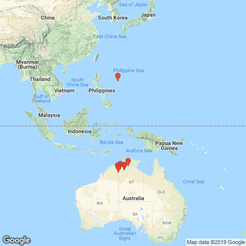
195 km W of Katherine, Victoria R, ca 1.5km upstream from bridge on Victoria Hwy (Shallow water, under rocks in gravel), Northern Territory, Australia [-15.6, 131.117 ± 10 km]

specimen
AMS_371676

Victoria R at Coolibah Stn Rd, Northern Territory, Australia [-15.555, 130.963 ± 100 m]

specimen
BMNH_44-1-12-7

Australia

specimen
BMNH_57-11-18-28

Victoria River

specimen
BMNH_44-1-12-160

Victoria River, N. Australia

specimen
BMNH_MP_367

Victoria River, N. Australia

specimen
INHS_16214

Katherine River, near the entrance to Katherine River Gorge National Park, Katherine, Northern Territory, Australia

specimen
AMNH_61955

Australia

specimen
ZMB_MP_0451

Australia

specimen
ZMB_MP_0458

Australia

specimen
BMNH_41-11-25-58-59

Victoria River, N Australia


WAM_S13773 Behn R, East Kimberley, nr Argyle Downs HS, Western Australia, Australia [-16.517, 128.917 > ± 100 km]

AMS_427109 Kununurra, Lake Kununurra at Kona caravan Park (In tube-like burrows in mud bank), Western Australia, Australia [-15.794, 128.719 ± 100 m]

WAM_S13757 Kununurra, irrigation area, main supply channel, Western Australia, Australia [-15.767, 128.733 ± 1 km]

WAM_S13758 Kununurra, irrigation area, main supply channel, Western Australia, Australia [-15.767, 128.733 ± 1 km]

WAM_S13759 Kununurra, irrigation area, main supply channel, Western Australia, Australia [-15.767, 128.733 ± 1 km]

WAM_S13756 Ord R system, ca 1.5 miles downstream from Old Lissadell HS, Rocky R Pool (On flats adjacent to deep muddy pool undercutting bank), Western Australia, Australia [-16.683, 128.55 ± 1 km]

AMS_427600 Ord R, 150m below Kununurra Diversion Dam, on W side of river (Under small rocks, steep bank, muddy gravel substrate, small backwater.), Western Australia, Australia [-15.791, 128.693 ± 100 m]

AMS_424069 Ord River, Ivanhoe crossing (Under rocks & ledges), Western Australia, Australia [-15.687, 128.687 ± 100 m]

AMS_427938 Victoria R, on Victoria Hwy (Under rocks & on surface of mud), Northern Territory, Australia [-15.615, 131.13 ± 100 m]

AMS_424068 Victoria River at Dashwood Crossing (see data sheet), Northern Territory, Australia [-16.334, 131.114 ± 100 m]

AMS_313605 Victoria River crossing (just off Hwy) (see datasheet), Northern Territory, Australia [-15.614, 131.13 ± 1 km]

Page updated: 07:10:53 Thu 04 Apr 2024

 
NSF icon MUSSEL icon
"Making the world a better place, one mollusk at a time."