|
Unionoidea | Unionidae | Gonideinae | Pseudodontini | Pseudodontina | Pilsbryoconcha species Pilsbryoconcha schomburgki (Martens, 1860): specimens
2 nominal species as synonyms
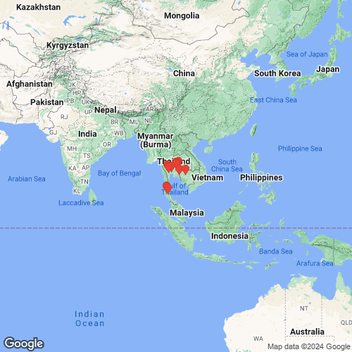
Range: Thailand. Map of Georeferenced Specimens
 |
Genbank Vouchers
ThailandRMBH_biv_1284_1 (COI, 16S, 28S) Thailand, Ta Pi River just E of Wat Aranyakham Wari (8.7522, 99.2370) MUMNH_UNI1522 (COI, 16S, 28S) Thailand: Tonle Sap Basin, Chanthaburi, Pong Nam Ron, Phraphut Stream (13° 02' 39.2" N, 102° 25' 05.1" E) MUMNH_UNI1514 (COI, 16S, 28S) Thailand: Mae Klong Basin, Ratchaburi, Ban Pong, Mae Klong River (13° 51' 28.7" N, 99° 49' 19.1" E) MUMNH_UNI2807 (COI, 16S, 28S) Thailand: Korat Plateau Basin, Nakhon Ratchasima, Lam Samlai Reservoir (14° 40' 09.1" N, 101° 52' 05.4" E) MUMNH_UNI0582 (COI, 16S, 28S) Thailand: Mae Klong Basin, Ratchaburi, Mueang, Mae Klong River (13° 34' 34.4" N, 99° 48' 59.7" E) RMBH_biv_1290 (COI, 16S, 28S) Thailand, Ta Pi River just N of Wat Pheng Praditsatha Ram (8.8445, 99.2018) MUMNH_UNI2800 (COI, 16S, 28S) Thailand: Korat Plateau Basin, Nakhon Ratchasima, Pak Thong Chai, Unnamed Stream (14° 41' 07.8" N, 102° 03' 55.4" E) MUMNH_UNI2810 (COI, 16S, 28S) Thailand: Korat Plateau Basin, Nakhon Ratchasima, Lam Phra Phloeng Stream (14° 27' 43.5" N, 101° 39' 38.0" E) MUMNH_UNI1523 (COI, 16S, 28S) Thailand: Tonle Sap Basin, Chanthaburi, Pong Nam Ron, Phraphut Stream (13° 02' 39.2" N, 102° 25' 05.1" E) MUMNH_UNI0836 (COI, 16S, 28S) Thailand: Malay Peninsular Eastern Slope Drainages, Nakhon Si Thammarat, Min Stream (8° 22' 52.5" N, 99° 31' 22.3" E) MUMNH_UNI2805 (COI, 16S, 28S) Thailand: Korat Plateau Basin, Nakhon Ratchasima, Sabpradu Reservoir (14° 50' 20.1" N, 101° 41' 06.8" E) MUMNH_UNI2797 (COI, 16S, 28S) Thailand: Korat Plateau Basin, Nakhon Ratchasima, Nong Ta Khong Pond (14° 56' 38.3" N,102° 09' 38.0" E) MUMNH_UNI1515 (COI, 16S, 28S) Thailand: Mae Klong Basin, Kanchanaburi, Taphoen Stream (14° 08' 13.8" N, 99° 22' 59.6" E)
|