|
Bivalvia | Unionoida | Hyrioidea | Hyriidae | Velesunioninae | Velesunio species Velesunio ambiguus (Philippi, 1847): specimens
19 nominal species as synonyms
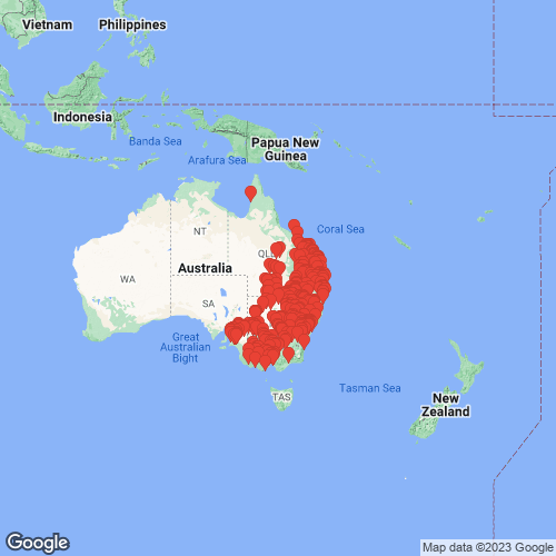
Range: Queensland to Southern Australia, eastern Australia. Map of Georeferenced Specimens
 |
Australia |

MNHN_MP_0038
Australia meridionale
|

AMS_125869
Darling River, Ana Branch,17km N of Wentworth, New South Wales, Australia [-33.967, 141.833 ± 10 km]
|

BMNH_MP_406
Yarra River, Melbourne, Australia
|

ANSP_334433
Clarence River, Australia
|

BMNH_MP_410
Victoria, Australia
|

ANSP_334434
Richmond River, N.S. Wales
|

AMS_126235
S of Sarina, Lotus Ck, Queensland, Australia [-22.4, 149.167 ± 10 km]
|

BMNH_20000228
Waranga Dam, Goulburn Valley, Australia
|

BMNH_MP_411
[no locality available - Australia]
|

BMNH_MP_412
Australia
|

BMNH_MP_413
Australia
|

ANSP_334435
Hunter River, N.S. Wales
|

USNM_84849
Australia
|

ANSP_341440
South Australia
|

ANSP_341442
South Australia
|

ANSP_341443
South Australia
|

ANSP_363602
Australia
|

AMS_126373
Gundagai, Murrumbidgee River, New South Wales, Australia [-35.067, 148.117 ± 10 km]
|

ANSP_41802
River Yarra, Victoria, Australia
|

UMMZ_111297
Bairnsdale, Victoria, Australia
|

UMMZ_111791
Victoria, Australia
|

UMMZ_111792
River Yarra, Melbourne Falls, Victoria, Australia
|

UMMZ_111793
Allbona Bay, Victoria, Australia
|

UMMZ_111795
Para River, 20 mi from Adelaide, Victoria, Australia
|

UMMZ_111796
South Australia
|

UMMZ_111797
New South Wales, Australia
|

UMMZ_111798
Murray River, South Australia
|

ANSP_65434
S. Para River, Gawler, S. Australia
|

ANSP_65436
North Para River, S. Australia
|

UMMZ_111802
Yarra River, South Australia
|

ANSP_71729
Murray R., nr. entr. L. Alexandrina, Aust.
|

ANSP_71734
S. Australia
|

ANSP_71735
Lake Alexandrina, mouth of Murray R., Aust.
|

ANSP_71736
Para River, Australia
|

ANSP_71737
Hope Valley Reservoir, nr. Adelaide, Aust.
|

UMMZ_111823
Lake Alexandria, South Australia
|

UMMZ_111824
Australia
|

UMMZ_111825
New Zealand [crossed out — must be Australia]
|

UMMZ_111826
South Australia
|

UMMZ_111829
River Murray, 80 mi E Adelaide, Victoria, Australia
|

UMMZ_111840
Lake Alexandria, Murray Mouth, South Australia
|

UMMZ_111851
New South Wales, Australia
|

FMNH_142710
Watson’s Creek, Greensborough, Victoria, Australia
|

FMNH_24521
South Australia
|

FMNH_142709
New South Wales, Australia
|

FMNH_21732
North Lake, Barmera, South Australia
|

FMNH_11202
Victoria, Australia
|

FMNH_21733
River Lachlan, Hillston, New South Wales, Australia
|

FMNH_120675
North Lake, South Australia
|

UMMZ_111899
Watsons Creek, Victoria, Australia
|

FMNH_109610
Lotus Creek, 104 mi S Mackay, North Queensland, Australia
|

FMNH_190536
Murray Bridge, South Australia
|

FMNH_90074
South Australia
|

UMMZ_111908
Australia
|

BMNH_1952-10-30-72
Australia
|

UMMZ_121207
Australia
|

UMMZ_22866
Narrabri, Australia
|

UMMZ_22870
Clarence River, Australia
|

INHS_16215
Lake Alexandrina, Potalloch, Lower River District, South Australia, Australia
|

INHS_11430
[Murrumbidgee River], Gundagai, New South Wales, Australia
|

UMMZ_248766
North Lake, Barmera, South Australia
|

CM_61.13040
Murray River, Murray Bridge, South Australia
|

CM_61.13317
Murray River, Australia
|

CM_61.1534
East coast of Australia
|

UMMZ_60354
North Lake, Barmera, South Australia
|

UMMZ_MP.603.1
North part of Australia
|

CM_61.5617
Gippsland, Victoria, Australia
|

MNHN_MP_1460
N.S. Wales
|

MNHN_MP_1464
River Murray
|

MNHN_MP_1470
Altona Bay, Victoria, Australia
|

MNHN_MP_1476
Rockhampton
|

MNHN_MP_1486
Port Fairy, Australia
|

MNHN_MP_1509
Bugle Ranges, Sud Australia
|

MNHN_MP_1506
River Avoca, Victoria
|

CM_61.6876
Billibong Creek (Murray River Dr.), New South Wales, Australia
|

MNHN_MP_1537
Nuelle Holland
|

MNHN_MP_1516
Nuelle Holland
|

CM_61.7679
Darling River, New South Wales, Australia
|

BMNH_MP_016
[no locality available - Australia]
|

BMNH_89-10-25-30-35
lagoon near Casio, Richmond River, NSW
|

BMNH_MP_079
Geelong, Queensland
|

BMNH_MP_080
New South Wales
|

BMNH_50-9-25-115
Abercrombie River, trib. of the Murray River
|

BMNH_46-9-16-76
South Australia
|

BMNH_88-3-23-2-5
South Creek, County of Cumberland, NSW
|

BMNH_50-9-25-116
South Creek, Australia
|

BMNH_1952-10-28-1
Membridge River
|

BMNH_51-5-28-5
Australia
|

BMNH_40-10-21
Australia
|

BMNH_59-10-12-103
Balonne and Bogan rivers
|

BMNH_46-10-7-6-9
Darling Downs, NSW
|

BMNH_40-10-21-22-23
Australia
|

BMNH_59-10-12-102
Bogan River
|

BMNH_91-11-6-283-294
Wallondilly River, Goulburn, NSW
|

BMNH_MP_100
Australia
|

BMNH_78-2-15-6
Cacupaspe River, Spring Plains, Victoria
|

BMNH_MP_101
[no locality available - Australia]
|

AMS_125922
Murray River at Mannum, Southern Australia, Australia [-34.917, 139.3 ± 1 km]
|

AMS_61903
Murray River, Murray Bridge, Southern Australia, Australia [-35.117, 139.267 ± 1 km]
|

AMS_125920
Lake Bonney, Barmera, Southern Australia, Australia [-34.25, 140.45 ± 1 km]
|

AMS_138824
Morgan, Murray River, Southern Australia, Australia [-34.033, 139.667 ± 1 km]
|

MCZ_MP.64
[no locality available - Australia]
|

AMS_1425
Murray River, SA
|

AMS_1426
Murray River, SA
|

AMS_375559
Murray River at Morgan, Southern Australia, Australia [-34.033, 139.65 ± 1 km]
|

AMS_47309-F
Lake Alexandrina, Lower Murray, Southern Australia, Australia [-35.467, 138.983 ± 10 km]
|

AMS_47309
Lake Alexandrina, Lower Murray, Southern Australia, Australia [-35.467, 138.983 ± 10 km]
|

AMS_62012
Murray River at Mannum, Southern Australia, Australia [-34.917, 139.3 ± 1 km]
|

AMS_57943
Dandenong, Victoria, Australia [-37.983, 145.217 ± 10 km]
|

AMS_125921
Blanchetown, Murray River, Southern Australia, Australia [-34.35, 139.617 ± 1 km]
|

AMS_61682
Mitchell River, Bairnsdale, Victoria, Australia [-37.833, 147.617 ± 10 km]
|

AMS_61701
Dandenong, Victoria, Australia [-37.983, 145.217 ± 10 km]
|

AMS_376217
Frankston Creek (FrankstonI?), Port Phillip, Victoria, Australia [-38.176, 145.127 ± 1 km]
|

AMS_47292
Yarra River, Victoria, Australia [-37.833, 145 ± 100 km]
|

BMNH_85-6-12-80-82
Isaac and Burnett rivers, Queensland
|

AMS_47300
Yarra River at Princes Bridge, Melbourne, Victoria, Australia [-37.807, 144.957 ± 1 km]
|

AMS_125919
Glenelg River at Dergholm near Casterton, Victoria, Australia [-37.367, 141.217 ± 1 km]
|

AMS_61692
Mitchell River, Bairnsdale, Victoria, Australia [-37.833, 147.617 ± 10 km]
|

AMS_47285
Lake Alexander, Victoria, Australia [-37.783, 142.833 ± 10 km]
|

AMS_61900
Box Creek, Cohuna, Victoria, Australia [-35.917, 144.217 ± 10 km]
|

AMS_69383
Hapiah Lake, near Mildura, Victoria, Australia [-34.183, 142.167 ± 100 km]
|

AMS_463
Stawell, Victoria, Australia [-37.06, 142.777 ± 1 km]
|

AMS_61704
Serpentine River, Loddon District, Victoria, Australia [-36.217, 143.933 ± 100 km]
|

AMS_61707
Wimmera River at Horsham, Victoria, Australia [-36.717, 142.2 ± 10 km]
|

AMS_62159
Lake Lonsdale, Victoria, Australia [-37.033, 142.633 ± 10 km]
|

AMS_47297
Lilydale, Victoria, Australia [-37.767, 145.35 ± 10 km]
|

AMS_61706
Murray River at Mannum, Southern Australia, Australia [-34.917, 139.3 ± 1 km]
|

AMS_47288
Yarra River, Victoria, Australia [-37.833, 145 ± 100 km]
|

AMS_47288B
Yarra River, Victoria, Australia [-37.833, 145 ± 100 km]
|

AMS_137217
Talgarno, Hume Weir, Victoria, Australia [-36.063, 147.158 ± 1 km]
|

AMS_61686
Wimmera River at Horsham, Victoria, Australia [-36.717, 142.2 ± 10 km]
|

AMS_126314
Benalla, Victoria, Australia [-36.55, 145.983 ± 10 km]
|

AMS_153271
Lake Menindee, SE shore near caravan park, New South Wales, Australia [-32.355, 142.408 ± 1 km]
|

AMS_61676
Darling River, Bourke, New South Wales, Australia [-30.1, 145.933 ± 10 km]
|

AMS_125889
Barwon R, Brewarrina, New South Wales, Australia [-29.95, 146.867 ± 10 km]
|

AMS_61897
Bogan River, at Peak Hill, New South Wales, Australia [-32.714, 148.136 ± 10 km]
|

AMS_125892
Cawndilla Crk, between Menindee Lake and Cawndilla Lake, NW from Kinchega Stn homestead, New South Wales, Australia [-32.42, 142.274 ± 10 km]
|

AMS_47296
Darling River, Bourke, New South Wales, Australia [-30.1, 145.933 ± 10 km]
|

AMS_47294
Hunter River, Muswellbrook, New South Wales, Australia [-32.267, 150.9 ± 10 km]
|

AMS_61723
Junction of Murray & Darling Rivers, reedy lake, New South Wales, Australia [-34.058, 141.867 ± 10 km]
|

AMS_61705
Wollondilly River, New South Wales, Australia [-34, 150 ± 100 km]
|

AMS_61708
Richmond River (Lagoon), New South Wales, Australia [-28.867, 153.05 ± 100 km]
|

AMS_61690
Nepean River nr Camden, New South Wales, Australia [-34.067, 150.7 ± 10 km]
|

AMS_61680
Murrumbidgee River at Leeton, New South Wales, Australia [-34.617, 146.383 ± 10 km]
|

AMS_170637
Murrumbidgee River at Leeton, New South Wales, Australia [-34.617, 146.383 ± 10 km]
|

AMS_61698
Murray River at Benthagi (Backwater), New South Wales, Australia
|

AMS_61687
Georges River at Liverpool, New South Wales, Australia [-33.929, 150.867 ± 1 km]
|

AMS_304691
Richmond River, New South Wales, Australia [-28.867, 153.05 ± 100 km]
|

AMS_125867
Murray River at Benthagi (Backwater), New South Wales, Australia
|

AMS_133341
Cowra, Wyangala Dam, NE bank, 1km NE from spillway, New South Wales, Australia [-33.971, 148.95 ± 10 km]
|

AMS_61671
Castlereagh River at Gilgandra, New South Wales, Australia [-31.717, 148.65 ± 10 km]
|

AMS_126329
Bland Creek near Marsden, New South Wales, Australia [-34.3, 147.8 ± 10 km]
|

AMS_57879
S of Leeton, Swamp at Blue Gate, near Yanco, New South Wales, Australia [-34.6, 146.4 ± 10 km]
|

AMS_61727
Murrumbidgee River at Wagga Wagga, New South Wales, Australia [-35.117, 147.383 ± 10 km]
|

AMS_2293
Cooma, Numeralla (Umerella) River, New South Wales, Australia [-36.143, 149.979 ± 100 km]
|

AMS_57945
Junction of Murray & Darling Rivers, reedy lake, New South Wales, Australia [-34.058, 141.867 ± 10 km]
|

AMS_57878
Leeton (Dried canal), New South Wales, Australia [-34.55, 146.4 ± 10 km]
|

AMS_47328
Walcha, Bergen-Op-Zoom Creek, New South Wales, Australia [-30.961, 151.552 ± 10 km]
|

AMS_61669
Bogan River, S of Nyngan, at "Cullubri", New South Wales, Australia [-31.964, 147.246 ± 1 km]
|

AMS_61668
Barwon River near Collarenebri (Billabongs), New South Wales, Australia [-29.55, 148.583 ± 10 km]
|

AMS_61678
Lake Narran (=Terewah) (Dried mud on shore), New South Wales, Australia [-29.867, 147.317 ± 10 km]
|

AMS_47282
Mooni (Moonie) River, near Collarenebri, New South Wales, Australia [-29.233, 148.65 ± 100 km]
|

AMS_12264
Lake Cargelligo, Lake Crk, New South Wales, Australia [-33.25, 146.417 ± 10 km]
|

AMS_125887
Burraburra Creek, Tributary of Abercrombie River, New South Wales, Australia [-34.233, 149.667 ± 100 km]
|

AMS_6503
Warren, Macquarie Rr, Gunningbar Ck, New South Wales, Australia [-31.717, 147.849 ± 10 km]
|

AMS_61666
60 km N (=40 mi NW) of Collenebri, W side of Mooni (Moonie R), Cambo Cambo Stn (=Cambo Stn), New South Wales, Australia [-29.08, 148.603 ± 10 km]
|

AMS_61673
Barwon Rr, 25 km above Brewarrina, New South Wales, Australia [-30.05, 147.083 ± 100 km]
|

AMS_62031
Menindee (=Menindie), New South Wales, Australia [-32.394, 142.414 ± 10 km]
|

AMS_125893
Euabalong, Booberoi Crk, W NSW, New South Wales, Australia [-33.072, 146.409 ± 100 km]
|

AMS_49127
Lagoon at Baan Baa near Namoi River, New South Wales, Australia [-30.6, 149.95 ± 10 km]
|

AMS_62030
Weetaliba near Binnaway, New South Wales, Australia [-31.578, 149.596 ± 1 km]
|

AMS_61679
Dumaresq River at Boggabilla, New South Wales, Australia [-28.617, 150.367 ± 1 km]
|

AMS_389837
Clarenza, New South Wales, Australia [-29.707, 153.018 ± 10 km]
|

AMS_125813
Macquarie River, Dundallamel, New South Wales
|

AMS_61689
Kemps Creek, West of Hoxton Park, New South Wales, Australia [-33.933, 150.667 ± 10 km]
|

AMS_125870
Sydney W, South Ck, trib. of Hawkesbury R, New South Wales, Australia [-33.717, 150.767 ± 100 km]
|

AMS_126325
Willandra, New South Wales, Australia [-33.195, 145.155 ± 1 km]
|

BMNH_MP_105
Victoria and Yeppoon Lagoon, Queensland
|

AMS_109977
NW of Balranald, Lake Arumpo, Top Hut Site, New South Wales, Australia [-33.8, 142.9 ± 10 km]
|

AMS_61902
Murrumbidgee R, at Griffith, irrigation area, New South Wales, Australia [-34.283, 146.033 ± 100 km]
|

AMS_30329
Georges River, above Liverpool Railway Bridge, New South Wales, Australia [-33.595, 150.927 ± 1 km]
|

AMS_47289
Wollondilly River, New South Wales, Australia [-34.283, 149.567 ± 100 km]
|

AMS_126242
Echuca, Murray River, Victoria, Australia [-36.133, 144.75 ± 10 km]
|

AMS_141795
Willandra Nat. Park, near Willandra Homestead (On banks of billabong), New South Wales, Australia [-33.19, 145.118 ± 10 km]
|

AMS_125895
Fish River at Oberon, New South Wales, Australia [-33.717, 149.867 ± 10 km]
|

AMS_125890
Bogan R, 65 km from Nyngan, New South Wales, Australia [-31.567, 147.167 ± 100 km]
|

AMS_126267
Sydney W, Nepean River near bridge, New South Wales, Australia [-33.75, 150.675 ± 100 km]
|

AMS_2698
Summer Hill Creek at Lucknow near Orange, New South Wales, Australia [-33.35, 149.167 ± 1 km]
|

AMS_167440
Richmond River at Casino, upstream from Irving Bridge (Gravel & small rock pools), New South Wales, Australia [-28.869, 153.042 ± 1 km]
|

AMS_61709
Clearfield Hill Railway Tank, between Grafton and Casino, New South Wales, Australia [-29.15, 152.933 ± 1 km]
|

AMS_88007
Lake Cargelligo at Lake Cargelligo, New South Wales, Australia [-33.283, 146.367 ± 10 km]
|

AMS_100742
Castlereagh River at Binnaway Rd, 14km S of Coonabarabran (Pool under bridge), New South Wales, Australia [-31.317, 149.333 ± 1 km]
|

AMS_33007
Mooni (Moonie) River N of Collarenebri, New South Wales, Australia [-29.05, 148.667 ± 10 km]
|

AMS_62014
Myrtle Creek between Richmond & Clarence Rivers, New South Wales, Australia [-29.083, 152.917 ± 10 km]
|

AMS_126281
Talbragar River, Cobbora, New South Wales, Australia [-32.05, 149.25 ± 1 km]
|

AMS_125894
W of Walgett, Lake Narran (Lake edge), New South Wales, Australia [-29.867, 147.317 ± 10 km]
|

AMS_84254
Trickiten Creek, Narran River, Angledool, N of Lightning Ridge (On creek bank), New South Wales, Australia [-29.1, 147.9 ± 1 km]
|

AMS_61665
Macquarie River at Warren, New South Wales, Australia [-31.7, 147.833 ± 10 km]
|

AMS_125814
Dubbo, Macquarie R, New South Wales, Australia [-32.25, 148.617 ± 10 km]
|

AMS_61683
Peel River at Tamworth, New South Wales, Australia [-31.092, 150.933 ± 10 km]
|

AMS_61882
Goulburn, Mulwaree Ponds, New South Wales, Australia [-34.95, 149.667 ± 100 km]
|

AMS_140526
Menindee Lake, Kinchega National Park, Menindee, New South Wales, Australia [-32.392, 142.417 ± 10 km]
|

AMS_61696
Ginninderra Creek near Canberra, New South Wales, Australia [-35.217, 149.05 ± 10 km]
|

AMS_154120
Kinchega National Park, Lake Cawndilla, SW of Menindee, New South Wales, Australia [-32.5, 142.233 ± 10 km]
|

AMS_168583
150 mi E of Tarago, S of Goulburn in Mulwaree Creek (Sandy mud), New South Wales, Australia [-35.07, 149.659 ± 1 km]
|

AMS_61887
Clarence River upper reaches at Woodenbong, New South Wales, Australia [-28.383, 152.617 ± 10 km]
|

AMS_125812
Sydney W, Eastern Creek, New South Wales, Australia [-33.822, 150.861 ± 10 km]
|

AMS_127152
Nana Creek, tributary of Nymboida and Clarence Rivers, New South Wales, Australia [-30.167, 152.967 ± 10 km]
|

AMS_125809
Coraki Aboriginal Station, New South Wales, Australia [-29, 153.267 ± 1 km]
|

AMS_404577
E of Rylstone, Rylstone Dam, Cudgegong R, at end of council access road (At water's edge, in sand, near submerged grasses), New South Wales, Australia [-32.792, 149.985 ± 1 km]
|

AMS_125810
SE of Cowra, Wyangala Dam, New South Wales
|

AMS_125886
Hunter River, New South Wales
|

AMS_61718
Barwon River, New South Wales; 30°05’S, 147°11’E
|

AMS_125868
Kings Creek, Darling River System, 1 mi N Clifton, New South Wales; 30°48’S, 144°08’E
|

AMS_126265
Richmond River, Clear Hills, New South Wales
|

AMS_83835
Esk, Brisbane River, Queensland, Australia [-27.233, 152.417 ± 10 km]
|

AMS_420518
Carpet Springs Stn, S of Bulloo Developmental Rd, waterholes in Yowah Ck (On wood & crawling along edges of waterhole in mud.), Queensland, Australia [-28.139, 144.864 ± 100 m]
|

AMS_400911
Paroo R, billabong 3km W of Wanaaring (Billabong), New South Wales, Australia [-29.707, 144.129 ± 100 m]
|

AMS_139359
Approx 10 mi from Balranald, Yanga Lake water storage, New South Wales, Australia [-34.733, 143.6 ± 10 km]
|

AMS_61672
Near Roma, Yuleba Ck, trib of Balonne R, Queensland, Australia [-26.65, 149.408 ± 1 km]
|

AMS_61677
Bulloo R at Thargomindah, Queensland, Australia [-27.983, 143.817 ± 10 km]
|

AMS_126234
Brisbane R near Fernvale, Queensland, Australia [-27.45, 152.64 ± 1 km]
|

AMS_125882
Beaudesert, Logan River (Lagoon), Queensland, Australia [-27.983, 153 ± 10 km]
|

AMS_125881
North Stradbroke Is, Queensland, Australia [-27.583, 153.408 ± 1 km]
|

AMS_125811
Cunnamulla, Queensland, Australia [-28.067, 145.683 ± 10 km]
|

AMS_125884
Lake Dartmouth, near Ambathalla, Queensland, Australia [-26.067, 145.3 ± 10 km]
|

AMS_61694
near Dalby, Condamine R, Queensland, Australia [-27.225, 151.167 ± 1 km]
|

AMS_411542
Humebo Ck, on road crossing to "Wombula" HS (On leaves & under rocks), Queensland, Australia [-28.174, 144.31 ± 100 m]
|

AMS_125888
St George, Balonne R, Queensland, Australia [-28.05, 148.583 ± 10 km]
|

AMS_126128
Brisbane, The Blunder, Blunder Ck, Queensland, Australia [-27.617, 152.983 ± 10 km]
|

AMS_126236
12 mi N of Miriam Vale, 12 Mile Ck, Queensland, Australia [-24.1, 151.467 ± 1 km]
|

AMS_61664
Warrego River at Charleville, Queensland, Australia [-26.4, 146.238 ± 10 km]
|

AMS_125876
approx 13km from Brisbane, at Brookfield, Gold Ck, Queensland, Australia [-27.5, 152.917 ± 1 km]
|

AMS_125880
Approx 1.5ml SE of Adavale, Blackwater Ck, Queensland, Australia [-25.9, 144.617 ± 10 km]
|

AMS_100752
11 ml (17.5km) W of Childers, Queensland, Australia [-25.317, 152.142 ± 1 km]
|

AMS_125775
Lake Manchester, Queensland, Australia [-27.483, 152.783 ± 10 km]
|

AMS_125879
Korenan, 60 miles N. of Bundaberg, Queensland, Australia [-24.467, 151.667 ± 1 km]
|

AMS_42562
Gin Gin Creek, near Bundaberg, Queensland, Australia [-24.933, 152.017 ± 10 km]
|

AMS_61886
Yeppen, near Rockhampton, Murray Lagoon, Queensland, Australia [-23.417, 150.5 ± 10 km]
|

AMS_61697
Watalgan, near Bundaberg, Queensland, Australia [-24.65, 152.017 ± 10 km]
|

AMS_125877
Barambah Ck, trib of Burnett R, Queensland, Australia [-25.617, 151.683 ± 1 km]
|

AMS_125878
Maryborough (In ponds), Queensland, Australia [-25.517, 152.7 ± 10 km]
|

AMS_47283
Wide Bay, Queensland, Australia [-24.9, 152.1 ± 10 km]
|

AMS_47291
Miriam Vale, Baffle Ck, Queensland, Australia [-24.333, 151.567 ± 10 km]
|

AMS_126239
S of Rockhampton, Gavial Ck, Queensland, Australia [-23.075, 150.858 ± 10 km]
|

AMS_61685
Yeppen, near Rockhampton, Murray Lagoon, Queensland, Australia [-23.417, 150.5 ± 10 km]
|

AMS_61700
Creek near Port Curtis, near Gladstone, Queensland, Australia [-23.917, 151.383 ± 10 km]
|

AMS_126238
Alligator Creek, 20 miles N of Rockhampton, Queensland, Australia [-23.142, 150.407 ± 1 km]
|

AMS_61889
Murray Lagoons, near Rockhampton, Queensland, Australia [-23.367, 150.517 ± 1 km]
|

AMS_47293
Port Curtis, Queensland, Australia [-23.917, 151.383 ± 10 km]
|

AMS_68931
W of Yeppoon, Lake Mary, Queensland, Australia [-23.117, 150.592 ± 1 km]
|

AMS_125875
Rockhampton, Fitzroy R Basin, Queensland, Australia [-23.333, 150.5 ± 1 km]
|

AMS_47286
Balonne River, Queensland
|

AMS_126233
Raglan Creek, 44 mi S Rockhampton, Queensland
|

AMS_12032
Balonne River, Queensland
|

AMS_61667
creek, near Brisbane, Queensland
|

AMS_61693
Alligator Creek and Fitzroy River, Queensland
|

AMS_118188
Mackenzie River, Queensland, Australia [-23.583, 149.733 ± 100 km]
|

AMNH_146529
Calliope River, Central Queensland, Australia
|

AMS_125952B
Gregory R, Proserpine District, Australia
|

AMS_12031
Burnett River, Bundaberg District, Queensland
|

AMS_126261
Perrys Creek, 16 mi NW Mackay, northern Queensland
|

AMS_126277
Murray & Yeppen Lagoons, Rockhampton, Queensland
|

AMS_61732
Frogmore Lagoon, Rockhampton, Queensland, Australia [-23.446, 150.539 ± 1 km]
|

AMS_62158
waterhole, Monet Estate, Rockhampton, Queensland
|

BMNH_MP_180
Macintyre River, NSW
|

BMNH_MP_189
Australia
|

AMNH_164767
Murray River, South Australia
|

USNM_85720
New South Wales, Australia
|

AMNH_35535
Australia
|

AMS_61892
Murray River, Murray Bridge, Southern Australia, Australia [-35.117, 139.267 ± 1 km]
|

AMNH_146524
Murray River, South Australia
|

AMNH_305999
Murray River, Victoria, Australia
|

BMNH_88-3-23-34
Numoi [?] River, NSW
|

BMNH_85-10-29-147
Yarra Yarra River, Victoria
|

USNM_623342
Murray R., Mannum, South Australia, Australia
|

AMNH_35528
Youlbourne Weir, Merrigum, Victoria, Australia
|

BMNH_86-7-26-321-324
Ropes Creek, near Rooty Hill, NSW
|

BMNH_89-10-25-45-47
Richmond River
|

BMNH_91-11-6-103-5
Port Curtis, Queensland
|

BMNH_88-3-23-14-16
Stanley River, Queensland
|

BMNH_88-3-23-11-13
Baffle Creek, Calliope River, Queensland
|

BMNH_78-2-15-7
Colibau River, Crawford Crossing, Victoria
|

AMS_401022
Comet R at Rolleston Rd crossing (Under stones), Queensland, Australia [-24.465, 148.62 ± 100 m]
|

BMNH_85-6-12-62-63`
Isaac and Burnett rivers, Queensland
|

BMNH_86-12-3-66-67
Port Curtis, Queensland
|

BMNH_88-3-23-6-10
South Creek, County of Cumberland, NSW
|

BMNH_88-11-28-4
Darling River
|

BMNH_99-10-25-36
Mitchell River, Victoria
|

USNM_127250
Narribri, New South Wales
|

USNM_170111
New South Wales, Australia
|

USNM_40809
New South Wales, Australia
|

USNM_40824
New South Wales, Australia
|

BMNH_88-3-23-1
South Creek, County of Cumberland, NSW
|

USNM_623343
Condamine R. Warwick, S. Qld., Australia
|

USNM_515312
Geoysi River, New South Wales, Australia
|

USNM_568974
Condamine River, Australia
|

USNM_623344
Samford, Queensland, Australia
|

BMNH_MP_103
Upper Falls of the River Yarra, Melbourne, Victoria
|

USNM_623286
Nullah Gully, 60 miles N Chinchilla, Queensland, Australia; Burnett Watershed
|

USNM_803663
Cuttaburra Creek, Boorobooka Water Hole, Queensland, Australia
|

USNM_623355
pond (billabong) approx. 5 miles W of Narranderra, Hay Road, New South Wales, Australia
|

USNM_515252
Condamine River, Darling Downs, Queensland, Australia
|

USNM_623341
Condamine River, Dalby, Queensland, Australia
|

USNM_623365
Katerapko Creek, Berri, So. Australia; trib Murray River
|

USNM_363025
Gracemere Lagoon, near Rockhampton, Queensland
|

USNM_568971
Canal Creek, Darling Downs, Australia
|

USNM_499963
Victoria, Australia
|

USNM_623354
Logan River, 4 miles N of Beaudesert, Queensland, Australia
|

BMNH_MP_083
[no locality available - Australia]
|

USNM_16489
River Murray and [locality illegible] S Austr.
|

USNM_126526
New Holland
|

USNM_853907
[no locality available - Australia]
|

USNM_120822
[no locality available - Australia]
|

USNM_879575
Queensland, Australia
|

AMNH_61929
Australia
|

AMNH_115753
North Lake, Barmera, South Australia
|

MCZ_72078
Balonne River, Queensland, Australia
|

MCZ_190274
backwater of Murray River at Benthagi, New South Wales, Australia
|

MCZ_190275
Railway water tank at Clearfield, between Grafton and Casino, New South Wales, Australia
|

MCZ_191129
Watson’s Creek, Victoria, Australia
|

MCZ_186726
Condamine River, near Dalby, Darling Downs, Queensland, Australia
|

MCZ_191951
Box Creek, tributary Murray River, Cohuna, Victoria, Australia
|

MCZ_72080
Murray River, Australia
|

UMMZ_111909
New South Wales, Australia
|

MCZ_110402
Murray River, Murray Bridge, South Australia
|

MCZ_103935
Lachlan River, Hillston, New South Wales, Australia
|

MCZ_186727
Murray River, Tartanga Lagoon, near Nildottie, South Australia
|

MCZ_196815
Fitzroy River Basin, Rockhampton, Queensland, Australia
|

MCZ_186729
Lac Genebal, Victoria, Australia
|

MCZ_191130
Bundaberg, Queensland, Australia
|

MCZ_37527
River Onkaparinga, South Australia, Australia
|

MCZ_191952
Clarence River, Woodenbong, New South Wales, Australia
|

MCZ_191953
Irrigation channel, creek near Lake Talbot Narrandera (Murrumbidgee River), New South Wales, Australia
|

MCZ_191954
tributary of Murrumbidgee River, at Griffith, New South Wales, Australia
|

MCZ_191955
Bogan River, Peak Hill, New South Wales, Australia
|

MCZ_191956
Moonie River, near Mogil Mogil, New South Wales, Australia
|

MCZ_98639
Murray River, Mannum, West of Adelaide, South Australia
|

MCZ_110401
Murray River, Murray Bridge, South Australia
|

MCZ_103936
Murray River, Murray Bridge, South Australia
|

MCZ_103937
Murray River, Murray Bridge, South Australia
|

MCZ_191959
Eastern Creek, Quakers Hill, near Sydney, New South Wales, Australia
|

MCZ_186728
in a billabong, near Barioon River, at Walgett, New South Wales, Australia
|

AMS_70500
Murray River, Swan Hill camping ground (river bank), Victoria, Australia [-35.333, 143.55 ± 10 km]
|

MCZ_72081
Sydney, New South Wales, Australia
|

MCZ_66333
Murray River, Tailem Bend, South Australia
|

MCZ_196817
Fitzroy River Basin, Rockhampton, Queensland, Australia
|

MCZ_191957
Murray Lagoon, Rockhampton, Queensland, Australia
|

MCZ_50893
Murray River, South Australia
|

MCZ_67977
Murray River, Tailem Bend, Russel, South Australia
|

MCZ_175536
Gawler River, South Australia
|

MCZ_104244
Murray River, Tailem Bend, Russel, South Australia
|

MCZ_191958
Mondellin, 10 mi S of junction of Murray and Darling rivers, Victoria, Australia
|

MCZ_191969
Dandendong, near Melbourne, Australia
|

MCZ_243496
Dawson River, Moura, 140 mi SW Rockhampton, Queensland, Australia
|

MCZ_231989
lower Murray River, South Australia
|

MCZ_221847
Australia
|

AMNH_31302
New Holland
|

AMNH_55048
Newlyn, Victoria, Australia
|

SBMHN_367450
Murray River, Murray bridge, South Australia
|

AMNH_30906
Australia
|

BMNH_57-11-18-29
Upper Victoria
|

AMNH_159309
Murray River, South Australia
|

SBMHN_367472
Torrens River, South Australia
|

AMNH_159323
Boyne River, near Gayndah, Queensland, Australia
|

AMS_125849
Condamine River, Queensland, Australia [-27.117, 149.8 ± 100 km]
|

AMNH_35337
South Australia
|

AMNH_93635
Murray River, Australia
|

ZMB_MP_0428
River Yarra, Victoria
|

SBMHN_27130
Murray River, North Lake, South Australia
|

ZMB_MP_0441
Australia
|

ZMB_MP_0462
Murrray River, Australia
|

ZMB_19079
Richmond River, New South Wales, Australia
|

ZMB_MP_0465
Gawler Fluss, New Holland
|

ZMB_46009
Queensland
|

ZMB_19082
Murray River, South Australia
|

ZMB_18668
Sydney, Australia
|

ZMB_MP_0459
Richmond River, New South Wales
|

ZMB_19418
N.S. Wales
|

ZMB_MP_0447
N.S. Wales
|

AMNH_261810
Yarra River, Australia
|

ZMB_9200A
Gawler fl., New South Wales, New Holland
|

ZMB_9083
Murray River
|

ZMB_37613
Toowoomba, Victoria, Australia
|

ZMB_19081
Murray River
|

ZMB_MP_0457
[no locality available - Australia]
|

ZMB_9083A
laggon bei Murray River, So Australia
|

ZMB_MP_0444
New South Wales
|

AMNH_35622
Australia
|

AMS_170166
Red Babs Creek, “Mayfield” HS, New South Wales, 31°20’S, 150°04’E
|

BMNH_MP_074
Victoria
|

BMNH_40-10-26-42
Lagoons of Lower Murray River, South Australia.
|

BMNH_54-7-19-65-66
Melbourne
|

AMS_87452
WNW of Inverell, SSE of Warialda, "Yuruga" Stn (In eroded creek bank, 2.5-3m below present level of land), New South Wales, Australia [-29.593, 150.593 ± 1 km]
|

USNM_84407
Australia
|

BMNH_41-4-29-103
Australia
|

BMNH_59-10-12-104
Bogan River, NSW
|

DMNH_150028
Murray River, Mildura, Victoria, Australia
|

DMNH_172899
Narribri, New South Wales, Australia
|

DMNH_172900
reservoir, Newlyn, Victoria, Australia
|

DMNH_172990
reservoir, Newlyn, Victoria, Australia
|

DMNH_172994
Gracemere Lagoon, near Rockhampton, Queensland, Australia
|

ANSP_189249
Balonne River, Australia
|

DMNH_186453
lagoon, Queensland, Australia
|

DMNH_227905
Bass Strait, Northern Tasmania, Australia
|

DMNH_48368
12 Mile Creek, near Miriam Vale, South Queensland, Australia
|

DMNH_65554
Rockhampton, Queensland, Australia
|

DMNH_78610
Watsons Creek, Greensburough, Victoria, Australia
|

DMNH_78613
Lake Alexander, Australia
|

BMNH_MP_109
Werribee River, Ballan, Victoria, Australia
|

BMNH_MP_111
N.S.W.
|

BMNH_MP_114
Newlyn, Victoria, Australia
|

BMNH_MP_119
Moreton Bay
|

BMNH_MP_121
Cobbin River, Victoria
|

BMNH_MP_124
South Para River, South Australia
|

BMNH_MP_125
South Para River, South Australia
|

BMNH_MP_132
Cobbin River, Victoria
|

BMNH_MP_135
Narribri, NSW
|

ANSP_125499
New South Wales
|

ANSP_125830
Murray River, Australia
|

ANSP_125838
Australia
|

ANSP_125840
Australia
|

ANSP_125841
Yarra River, Australia
|

ANSP_125843
Murray River, Australia
|

ANSP_125844
Australia
|

BMNH_54-11-9-3
[Australia]
|

AMS_383627
Darling R, "Brian Murrays Pdk", Curranyalpa Block, New South Wales, Australia [-30.882, 144.696 ± 1 km]
|

BMNH_1958-4-3-1
Australia
|

AMS_61699
Murray River at Benthagi (Backwater), New South Wales, Australia
|

AMS_61691
Nepean River nr Camden, New South Wales, Australia [-34.067, 150.7 ± 10 km]
|

AMS_12003
Richmond River, New South Wales, Australia [-28.867, 153.05 ± 100 km]
|

AMS_61725
Rockhampton, Queensland, Australia [-23.367, 150.533 ± 10 km]
|

AMS_61721
Murrumbidgee River at Leeton, New South Wales, Australia [-34.617, 146.383 ± 10 km]
|

AMS_61684
Benalla, (Broken Creek), Victoria, Australia [-36.55, 145.983 ± 100 km]
|
|
|
AMS_75140 16 km SW of Gladstone (Open gum forest), Queensland, Australia [-24, 151.217 ± 10 km]
AMS_100842 16 km SW of Wee Waa,on Pilliga Rd, Brigalow Creek, W side of bridge (On sandy mud around pool), New South Wales, Australia [-30.316, 149.294 ± 10 km]
AMS_100841 17 km S of Narrabri, Bohena Creek on Newell Highway E of road bridge (Round pool on sand/mud), New South Wales, Australia [-30.447, 149.671 ± 1 km]
AMS_396515 17 km S of Narrabri, Bohena Creek on Newell Highway, 100m E of road bridge (In sandy mud, in isolated pools), New South Wales, Australia [-30.447, 149.671 ± 1 km]
AMS_404110 2 small billabongs on E side of Macquarie R near Willancorah Stn (4km from `main rd') Macquarie Marshes (on leaves on bottom of pool), New South Wales, Australia [-30.9, 147.5 ± 1 km]
AMS_110102 20 km S of Forbes, on Newell Hwy (River or billabong), New South Wales, Australia [-33.49, 147.827 ± 10 km]
AMS_74851 23 km from Griffith (In swamp, 45m from edge), New South Wales, Australia [-34.283, 146.033 ± 100 km]
AMS_404948 25 km NW of Griffith, Willow Dam - Barren Box Swamp, drainage channel (Channel with soft mud, plants, flowing), New South Wales, Australia [-34.183, 145.828 ± 1 km]
AMS_173356 30km N of Maryborough, SW of Howard, Upper Burrum R, Harwood Ck (In creek bed & on banks), Queensland, Australia [-25.433, 152.483 ± 10 km]
AMS_422519 6 miles W of Stawell, Victoria, Australia [-37.05, 142.725 ± 10 km]
AMS_421788 Alice R, "North Delta" HS (Dry creek bed), Queensland, Australia [-23.669, 145.589 ± 100 m]
AMS_173490 Approx 91km NE of Miles, 4km W of Wandoan, Queensland, Australia [-26.133, 149.917 ± 10 km]
AMS_149368 Apsley River, above Apsley Falls, Apsley Gorge National Park (rocky bottom, on bank), New South Wales, Australia [-31.052, 151.768 ± 1 km]
AMS_126125 Archers, Gracemere, near Rockhampton, Queensland, Australia [-23.433, 150.45 ± 10 km]
AMS_381213 Balonne R, at Bindle, Queensland, Australia [-27.667, 148.75 ± 10 km]
AMS_404102 Baranbah Ck, on side rd from Ban Ban Springs, at ford (near Research Stn) & Ban Ban HS (Under rocks & in creek), Queensland, Australia [-25.685, 151.778 ± 100 m]
AMS_327362 Barton Creek, just S of Roma-Taroom Rd (Billabing at side of creek, in flood debris and mud along edges), Queensland, Australia [-26.057, 149.256 ± 100 m]
AMS_396519 Bathurst, Sir Joseph Banks Nature Park (In dam), New South Wales, Australia [-33.433, 149.575 ± 10 km]
AMS_125848 Beaudesert, Logan River, Walkers Lagoon, Queensland, Australia [-27.983, 153 ± 10 km]
AMS_125891 Bective, Peel River, near Tamworth (Lagoon), New South Wales, Australia [-30.97, 150.735 ± 10 km]
AMS_334243 Billabong on road between Munginda and St George (on wood), Queensland, Australia [-28.513, 148.846 ± 100 m]
AMS_314469 Billabong, Paroo River, New South Wales, Australia [-29.707, 144.129 ± 100 m]
AMS_61681 Bogan River near Nyngan, New South Wales, Australia [-31.567, 147.2 ± 10 km]
AMS_126375 Boggabilla, Queensland, Australia [-28.617, 150.367 ± 10 km]
AMS_396520 Bohena Ck, 11km from Narrabri, on Culgoora Rd, 300m S of rail bridge. (In residual pools), New South Wales, Australia [-30.325, 149.69 ± 1 km]
AMS_396521 Bohena Ck, 11km from Narrabri, on Culgoora Rd, 300m S of rail bridge., New South Wales, Australia [-30.325, 149.69 ± 1 km]
AMS_404958 Booberoi Ck, between Lake Cargelligo & Mt. Hope, New South Wales, Australia [-33.138, 146.29 ± 10 km]
AMS_396517 Box Creek, Cohuna, Victoria, Australia [-35.917, 144.217 ± 10 km]
AMS_126344 Brewarrina, Barwon River, New South Wales, Australia [-29.95, 146.867 ± 10 km]
AMS_126395 Brewarrina, Barwon River, New South Wales, Australia [-29.95, 146.867 ± 10 km]
AMS_396513 Brigalow Creek, 50m W of road bridge on Wee Waa - Pillaga Rd (Isolated residual pool), New South Wales, Australia [-30.312, 149.293 ± 1 km]
AMS_125847 Brisbane, Belmont, Queensland, Australia [-27.517, 153.117 ± 10 km]
AMS_430726 Brisbane, Norman Creek near Holland Park, Queensland, Australia [-27.5, 153.067 ± 10 km]
AMS_430724 Brisbane, Rocklea, Queensland, Australia [-27.548, 153.005 ± 1 km]
AMS_430690 Broken River at Swanpool, Victoria, Australia [-36.746, 146.008 ± 1 km]
AMS_125873 Bulloo R at Thargomindah, Queensland, Australia [-27.983, 143.817 ± 10 km]
AMS_430723 Bulloo R at Thargomindah, Queensland, Australia [-27.983, 143.817 ± 10 km]
AMS_110101 Cargelligo Weir, near "Sheet of Water" Lake, New South Wales, Australia [-33.202, 146.451 ± 1 km]
AMS_126311 Casino, Richmond River, New South Wales, Australia [-28.867, 153.033 ± 10 km]
AMS_435774 Clarence R, at Baryulgil crossing, New South Wales, Australia [-29.217, 152.562 ± 1 km]
AMS_404949 Clarence River upper reaches at Woodenbong, New South Wales, Australia [-28.383, 152.617 ± 10 km]
AMS_421786 Condamine R, Condamine, below weir at bridge (Isolated pools in rocky sandy/gravel ck; under rocks at edge of pools.), Queensland, Australia [-26.926, 150.13 ± 100 m]
AMS_380836 Condamine R, at Condamine (Found washed up on gravel sides in shoal area), Queensland, Australia [-26.928, 150.129 ± 100 m]
AMS_61675 Condamine R, nr Cecil Plains, Queensland, Australia [-27.533, 151.2 ± 10 km]
AMS_84892 Condobolin area, Booberoi (Booberi) Creek, around Round Hill Rd bridge, New South Wales, Australia [-33.139, 146.29 ± 100 km]
AMS_404983 Condobolin area, Booberoi Ck, N side of Round Hill road bridge (Mostly buried in muddy substrate with numerous weed patches.), New South Wales, Australia [-33.139, 146.29 ± 100 km]
AMS_73424 Creek near Mt. Harris, ca. 48km (30mls) N of Warren, New South Wales, Australia [-31.3, 147.667 ± 10 km]
AMS_360011 Creswick, ca. 15km NW Ballarat (In dam), Victoria, Australia [-37.433, 143.9 ± 10 km]
AMS_100839 Cudgegong River, N of Rylstone, 100m E of rail bridge (Gravel bottom with silt & reeds), New South Wales, Australia [-32.792, 149.971 ± 1 km]
AMS_173156 Darling River at Kinchega National Park, Menindee (River bank), New South Wales, Australia [-32.399, 142.414 ± 10 km]
AMS_125885 Darling River, just S of Menindee (In billabong), New South Wales, Australia [-32.4, 142.417 ± 1 km]
AMS_404163 Dawson R at Taroom, Queensland, Australia [-25.645, 149.795 ± 100 m]
AMS_421785 Dawson R, W of Springsure, off Dawson Hwy, nr Moura Weir, Queensland, Australia [-24.6, 149.91 ± 100 m]
AMS_421793 Dawson R, W of Springsure, off Dawson Hwy, nr Moura Weir, Queensland, Australia [-24.6, 149.91 ± 100 m]
AMS_173130 Deniliquin, Edward River, New South Wales, Australia [-35.533, 144.967 ± 10 km]
AMS_61674 Deniliquin, Edward River, New South Wales, Australia [-35.533, 144.967 ± 10 km]
AMS_126350 Deniliquin, Edward River, New South Wales, Australia [-35.533, 144.967 ± 10 km]
AMS_426331 E of Rylstone, Cudgegong R, Rylstone Dam, at end of council access road (On mud at water's edge), New South Wales, Australia [-32.792, 149.985 ± 1 km]
AMS_435772 Eastern Creek, opp Raceway, New South Wales, Australia [-33.822, 150.861 ± 10 km]
AMS_341631 Elliot River on Isis Hwy (In sandy mud in small pools), Queensland, Australia [-25.014, 152.195 ± 100 m]
AMS_91359 Esk, Brisbane River, Queensland, Australia [-27.233, 152.417 ± 10 km]
AMS_404162 Fairy Bower, ca 6 mis SW of Rockhampton, Queensland, Australia [-23.403, 150.466 ± 1 km]
AMS_126364 Fitzroy R at Duaringa, Queensland, Australia [-23.627, 150.108 ± 100 km]
AMS_173137 Four Mile Creek, New England Highway, S of Tenterfield, New South Wales, Australia [-29.265, 149.986 ± 1 km]
AMS_327791 Frogmore Lagoon, Rockhampton (under rocks and wood along edges[viviparids]; on wood [glyptophysa, segmentina and Lymnaea]), Queensland, Australia [-23.446, 150.539 ± 100 m]
AMS_126367 Georges River near Sydney, New South Wales, Australia [-33.95, 150.8 ± 100 km]
AMS_126406 Georges River near Sydney, New South Wales, Australia [-33.95, 150.8 ± 100 km]
AMS_126335 Gilgandra, Castlereagh River, New South Wales, Australia [-31.717, 148.667 ± 10 km]
AMS_173143 Gilgandra, Castlereagh River, New South Wales, Australia [-31.717, 148.667 ± 10 km]
AMS_430727 Gladstone, Queensland, Australia [-23.863, 151.234 ± 10 km]
AMS_430695 Goulburn River at Longwood, Victoria, Australia [-36.8, 145.417 ± 10 km]
AMS_61688 Goulburn, New South Wales, Australia [-34.761, 149.72 ± 10 km]
AMS_396518 Griffith, New South Wales, Australia [-34.283, 146.033 ± 10 km]
AMS_126392 Gundagai, Murrumbidgee River, New South Wales, Australia [-35.067, 148.117 ± 10 km]
AMS_173155 Gundagai, Murrumbidgee River, New South Wales, Australia [-35.067, 148.117 ± 10 km]
AMS_430730 Ipswich, Booval (Bundamba Creek), Queensland, Australia [-27.611, 152.805 ± 10 km]
AMS_404103 Jordan R, at Jericho, on Capricorn Hwy (Alice R Drainage), Queensland, Australia [-23.599, 146.133 ± 100 m]
AMS_404232 Jordan R, at Jericho, on Capricorn Hwy (Alice R Drainage), Queensland, Australia [-23.599, 146.133 ± 100 m]
AMS_126402 Kalka Ck, near Rockhampton, Queensland, Australia [-23.383, 150.483 ± 100 km]
AMS_173153 Kemps Creek, West of Hoxton Park, New South Wales, Australia [-33.933, 150.667 ± 10 km]
AMS_411607 Kinchega NP, at Ranger stn / Woolshed, New South Wales, Australia [-32.471, 142.346 ± 100 m]
AMS_409082 Kinchega Nat. Park, Lake Menindee (At edge of lake), New South Wales, Australia [-32.401, 142.369 ± 1 km]
AMS_173141 Kinchega National Park, Menindee, New South Wales, Australia [-32.393, 142.418 ± 10 km]
AMS_404160 Korenan, 60miles N. of Bundaberg, Queensland, Australia [-24.467, 151.667 ± 1 km]
AMS_330863 Lagoon at Narrabri, New South Wales, Australia [-30.333, 149.783 ± 10 km]
AMS_411612 Lake Boga, E of Swan Hill, Victoria, Australia [-35.453, 143.628 ± 100 m]
AMS_126287 Leeton, New South Wales, Australia [-34.55, 146.4 ± 10 km]
AMS_158379 Lion Creek, near Rockhampton, Queensland, Australia [-23.362, 150.478 ± 10 km]
AMS_99285 Macquarie River, 5km N of Warren, New South Wales, Australia [-31.667, 147.805 ± 10 km]
AMS_409083 Mallee Cliffs State Forest, Tributary of Murray River (At edge), New South Wales, Australia [-34.51, 142.413 ± 1 km]
AMS_89051 Marra (=Murra) Ck, trib. of Macquarie R., NW of Warren, New South Wales, Australia [-31.217, 143.502 ± 10 km]
AMS_100835 Marthaguy Ck., trib of Macquarie R, W of Carinda (On muddy banks), New South Wales, Australia [-30.457, 147.681 ± 10 km]
AMS_396516 Menindee Lake, Kinchega National Park, Menindee (Along edge of water, in mud.), New South Wales, Australia [-32.392, 142.417 ± 10 km]
AMS_421787 Miles, Chinamans Lagoon (billabong) (Under & on rocks & in weed at billabong edge.), Queensland, Australia [-26.669, 150.187 ± 100 m]
AMS_61905 Mooni (Moonie) River at Mogil Mogil Homestead, New South Wales, Australia [-29.35, 148.683 ± 1 km]
AMS_327358 Mooni River, Queensland, Australia [-28.343, 148.832 ± 100 m]
AMS_308489 Moora Moora Reservoir, Grampians, Victoria, Australia [-37.233, 142.417 ± 1 km]
AMS_404975 Mororo, on Don McLaren's property (Dam), New South Wales, Australia [-29.333, 153.233 ± 10 km]
AMS_330381 Mount George, New South Wales, Australia [-31.883, 152.183 ± 10 km]
AMS_173162 Mulwaree Ponds, Goulburn, New South Wales, Australia [-34.783, 149.667 ± 10 km]
AMS_62161 Murray Lagoons, Rockhampton, Queensland, Australia [-23.367, 150.517 ± 1 km]
AMS_125916 Murray River at Mannum, Southern Australia, Australia [-34.917, 139.3 ± 1 km]
AMS_358674 Murrumbidgee River at Wagga Wagga, New South Wales, Australia [-35.117, 147.383 ± 10 km]
AMS_419925 N of Bourke, E side of Mitchell Hwy, Warrego R overflow (Waterholes), New South Wales, Australia [-29.349, 145.863 ± 100 m]
AMS_127154 NW of Miriam Vale, approx 7mls NNW of Bororen (In waterhole), Queensland, Australia [-24.317, 151.542 ± 10 km]
AMS_99503 Namoi River, Narrabri, Old Gunedah Rd, Tarriaro (=Terriara) Bridge (On mud bank in river), New South Wales, Australia [-30.396, 149.894 ± 1 km]
AMS_327365 Narran Lake (shallow, muddy pools), New South Wales, Australia [-29.698, 147.438 ± 100 m]
AMS_126448 Narrandera, Murrumbidgee River, New South Wales, Australia [-34.751, 146.546 ± 10 km]
AMS_61899 Narrandera, near Lake Talbot (irrigation channel), New South Wales, Australia [-34.751, 146.567 ± 10 km]
AMS_430729 Near Roma, Yuleba Creek at Yuleba, off Balonne R, Queensland, Australia [-26.613, 149.383 ± 1 km]
AMS_404962 Nenegara waterhole, Paroo Rd. at Wanaaring, New South Wales, Australia [-29.7, 144.15 ± 10 km]
AMS_432617 Nepean R, Menangle Bridge, New South Wales, Australia [-34.119, 150.739 ± 100 m]
AMS_432611 Nepean River at Douglas Park, New South Wales, Australia [-34.194, 150.712 ± 10 km]
AMS_174671 Nepean River, Camden, New South Wales, Australia [-34.05, 150.7 ± 10 km]
AMS_358670 Nepean River, Camden, New South Wales, Australia [-34.073, 150.699 ± 10 km]
AMS_173349 Nepean River, Menangle (buried in gravel in pond, low river level), New South Wales, Australia [-34.133, 150.748 ± 1 km]
AMS_358667 Nepean River, Menangle, New South Wales, Australia [-34.119, 150.737 ± 10 km]
BMNH_59-10-12-104-106 Nepean and Bogan rivers, Australia
AMS_434727 Paddys R at Hume Hwy (Pool with soft mud bottom), New South Wales, Australia [-34.647, 150.125 ± 1 km]
AMS_414984 Paddys R, under freeway bridge (=Hume Hwy bridge?) (Silt on pool bottom), New South Wales, Australia [-34.643, 150.125 ± 1 km]
AMS_404101 Paroo R, 1km N of Hungerford, on Hwy between Hungerford & Eulo (Series of pools & mud in otherwise dry riverbed.), Queensland, Australia [-28.983, 144.407 ± 100 m]
AMS_404107 Paroo R, 1km N of Hungerford, on Hwy between Hungerford & Eulo (Series of pools & mud in otherwise dry riverbed.), Queensland, Australia [-28.983, 144.407 ± 100 m]
AMS_47287 Port Curtis, Queensland, Australia [-23.917, 151.383 ± 10 km]
AMS_303838 Rickabys Creek, near Londonderry, Sydney (On dry bank near pool & 5-25cm below surface in dry bed), New South Wales, Australia [-33.648, 150.752 ± 10 km]
AMS_379936 Rockhampton, Queensland, Australia [-23.367, 150.533 ± 10 km]
AMS_125874 Roma, Queensland, Australia [-26.583, 148.783 ± 10 km]
AMS_404968 SE of Cowra, Wyangala Dam, New South Wales, Australia [-33.971, 148.95 ± 1 km]
AMS_100840 SE of Narrabri, Tulla Mullen (=Mallin) Creek, New South Wales, Australia [-30.589, 149.886 ± 10 km]
AMS_100750 SE of Narrabri, junction of Namoi River and Bibbla Creek, New South Wales, Australia [-30.448, 149.946 ± 1 km]
AMS_140519 SW of Gympie, Eel Ck, on Eel Ck Rd (Small weedy creek with sandy bottom), Queensland, Australia [-26.231, 152.633 ± 1 km]
AMS_379935 Sandy Creek Bridge on Juandah Creek on Roma - Taroom Rd (in drying pool), Queensland, Australia [-25.68, 149.804 ± 100 m]
AMS_420520 Sandy Creek Bridge on Juandah Creek on Roma - Taroom Rd (in drying pool), Queensland, Australia [-25.68, 149.804 ± 100 m]
AMS_425848 Severn R at rd to Macintyre Falls, New South Wales, Australia [-29.152, 150.967 ± 10 km]
AMS_125815 South Creek near Sydney, New South Wales, Australia [-33.817, 150.767 ± 100 km]
AMS_61670 South Grafton, Bardens(?) Creek, New South Wales, Australia [-29.7, 152.933 ± 1 km]
AMS_404947 Sydney NW, Beecroft reservoir, New South Wales, Australia [-33.75, 151.067 ± 10 km]
AMS_61898 Sydney W, Eastern Creek, at Quakers Hill, New South Wales, Australia [-33.73, 150.87 ± 10 km]
AMS_71392 Sydney W, Prospect, Eastern Creek (Small sluggish heavily polluted creek), New South Wales, Australia [-33.792, 150.863 ± 1 km]
AMS_125917 Tailem Bend, River Murray, Southern Australia, Australia [-35.25, 139.467 ± 10 km]
AMS_435769 Talbragar R at Boomey Rd, New South Wales, Australia [-32.108, 149.092 ± 1 km]
AMS_100753 Talbragar River, 1km N of Dunedoo (Mud & gravel), New South Wales, Australia [-32, 149.4 ± 10 km]
AMS_61702 Tamworth, New South Wales, Australia [-31.102, 150.925 ± 10 km]
AMS_125872 Thallon, Queensland, Australia [-28.633, 148.867 ± 10 km]
AMS_126257 Thargomindah, Queensland, Australia [-27.983, 143.817 ± 10 km]
AMS_314488 Trangie, WNW of Dubbo (billabongs), New South Wales, Australia [-32.034, 147.988 ± 100 m]
AMS_419924 Tuen Ck, next to Mitchell Hwy, creek crossing (Under rocks at edge of pools in creek bed.), Queensland, Australia [-28.565, 145.713 ± 100 m]
MNHN_mp_1476_2 Victoria
AMS_126106 W of Coonamble, "Mutamaa" ="Muttama" Stn, near Garrawilla Watercourse, bore dam, New South Wales, Australia [-30.908, 148.045 ± 10 km]
AMS_409084 W of Wentworth, Rufus River, adjacent to outflow from Lake Victoria (In water weed), New South Wales, Australia [-34.05, 141.276 ± 100 m]
AMS_311534 Walcha, S. side of town, Apsley Rd (Small river, sand, rock, gravel & some mud in side pools.), New South Wales, Australia [-30.988, 151.593 ± 100 m]
AMS_126353 Walgett, Barwon River, New South Wales, Australia [-30.183, 148.118 ± 10 km]
AMS_126291 Walgett, New South Wales, Australia [-30.183, 148.118 ± 10 km]
AMS_173147 Walgett, billabong near Barwon River, New South Wales, Australia [-30.016, 148.118 ± 10 km]
AMS_126390 Walgett, near Barwon River (Billabong), New South Wales, Australia [-33.016, 148.118 ± 10 km]
AMS_173131 Walla Walla, near Albury, New South Wales, Australia [-35.767, 146.9 ± 10 km]
AMS_126333 Ward R, 12mls W of Charleville, Queensland, Australia [-26.333, 145.583 ± 10 km]
AMS_314481 Warrego R at Charleville, Queensland, Australia [-28.019, 145.749 ± 100 m]
AMS_430722 Warrego River at Charleville, Queensland, Australia [-26.4, 146.238 ± 10 km]
AMS_125864 Warwick, Queensland, Australia [-28.217, 152.033 ± 10 km]
AMS_125865 Warwick, Queensland, Australia [-28.217, 152.033 ± 10 km]
AMS_126299 Watalgan, near Bundaberg, Queensland, Australia [-24.65, 152.017 ± 10 km]
AMS_126304 Watalgan, near Bundaberg, Queensland, Australia [-24.65, 152.017 ± 10 km]
AMS_354133 Wee Waa, on SW side of town next to cotton crop at beginning of Pillaga Rd (On mud & weed in small pool along side small creek), New South Wales, Australia [-30.247, 149.433 ± 1 km]
AMS_430689 Wimmera River at Dimboola, Victoria, Australia [-36.454, 142.021 ± 1 km]
AMS_430693 Wimmera River at Horsham, Victoria, Australia [-36.721, 142.208 ± 10 km]
AMS_120372 Wyangala Dam, 36km E of Cowra, 1km upstream from dam wall (6m above water level- drought conditions), New South Wales, Australia [-33.973, 149.939 ± 1 km]
AMS_125883 Yeppen Lagoon, Rockhampton, Queensland, Australia [-23.417, 150.5 ± 10 km]
AMS_56575 Yeppen Lagoon, near Rockhampton, Queensland, Australia [-23.417, 150.5 ± 10 km]
AMS_404161 Yeppen, near Rockhampton, Murray Lagoon, Queensland, Australia [-23.417, 150.5 ± 10 km]
AMS_423043 Zamia Ck, Queensland, Australia [-24.611, 149.37 ± 100 m]
BMNH_mp_095 [no locality available - Australia]
AMS_125969 [presumably Australia]
AMS_433214 approx 20km S of Walcha, Apsley R, opposite "Pine Glen" HS, New South Wales, Australia [-31.187, 151.652 ± 1 km]
AMS_422338 ca 6.5km (4mls) E of Wodonga, on Wodonga-Tallangatta rd, swampy ck flowing into Murray R (In mud), Victoria, Australia [-36.14, 146.955 ± 1 km]
AMS_404951 ca. 30.5km (19mls) NW of Lake Cargelligo (Muddy bank of drying creek), New South Wales, Australia [-33.208, 146.367 ± 10 km]
|
New Zealand |

ANSP_41803
New Zealand
|
|
|
unknown |

MNHN_MP_1459
[no locality available - Africa]
|
|
|
Genbank Vouchers
AustraliaBivAToL-379 (COI, 16S, ND1, 28S, 18S, H3) Nepean R., New South Wales
FMNH_337195_1 (COI, 16S, 28S) FMNH_337195_2 (COI, 16S, 28S) FMNH_337195 (16S) BivAToL-172 (Cytb) FMNH 337195 (ND1)
|