| Page last updated
26 December 2007 |
Freshwater Mussels of Angola
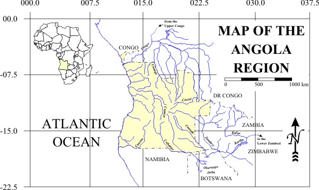
Map of Angola. The Republic of Angola is located in southwestern Africa. With a land area of roughly 1,246,700 km2, the country is almost twice the size of Texas and seventh largest on the continent. The main, southern body of Angola is situated between -6° and -18° latitude and bounded to the north by the Democratic Republic of the Congo, to the east by Zambia and by Namibia to the south. To the west, the Atlantic delimits a 1600 km coastline. The coastal enclave of Cabinda occupies roughly 7270 km2 between the DRC and the Republic of the Congo.
The physical geography of Angola is varied, with a narrow strip of coastal plain rising to highlands that form the western extent of the High Plateau, the “backbone” of southern and eastern Africa. These highlands form a complicated divide that drains Angola's waters in various directions. The western part of the country drains directly to the Atlantic, the major streams being the Cuanza (sometimes transliterated as Kwanza) and the Cunene (or Kunene). To the north and east, rivers flow to the Congo, either to the Lower Congo directly or via several streams in the Cassai (= Kasai) basin. The remainder in the southwest (that do not evaporate in the endorheic basins of the Okavango and the Etosha Pan) drain to the Indian Ocean via the Zambezi River.
|