|
Unionoida | Unionoidea | Unionidae | Ambleminae | Lampsilini | Cyprogenia species Cyprogenia aberti (Conrad, 1850): specimens
4 nominal species as synonyms
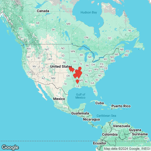
Range: Ozark Plateau, North America. Map of Georeferenced Specimens
 |
Genbank Vouchers
USAUAUC_1647 (COI, ND1) USA, Kansas, Wilson County, Fall River near Fredonia (37.51187, -95.83964) UAUC_2724 (COI, ND1) UAUC_2377 (COI, ND1) UAUC_2378 (COI, ND1) UAUC_1650 (COI, ND1) USA, Arkansas, Newton County, Buffalo River, upstream from Hwy 123 (36.17806, -92.42583) UAUC_2375 (COI, ND1) UAUC_76 (COI, ND1) Saline R., Saline Co., Arkansas UAUC_2384 (COI, ND1) UAUC_2726 (COI, ND1) UAUC_1652 (COI, ND1) USA, Arkansas, Sharp County, Strawberry River, 0.5 Km upstream of Sloan Cr. (36.11194, -91.62111) UAUC_1537 (COI, ND1) USA, Arkansas, Clay County, Current River, 3.8 mi S MO-AR border on Hwy 211 (36.25306, -90.9125) UAUC_1654 (COI, ND1) USA, Arkansas, Tipton County, White River, RM 230 (Dean Bar) (35.43333, -90.00611) UAUC_1646 (COI, ND1) USA, Kansas, Wilson County, Fall River near Fredonia (37.51187, -95.83964) UAUC_1838 (COI, ND1) USA, Arkansas, Pike County, Caddo River, near Amity (34.26472, -93.46083) UAUC_1536 (COI, ND1) USA, Arkansas, Clay County, Current River, 3.8 mi S MO-AR border on Hwy 211 (36.25306, -90.9125) UAUC_1837 (COI, ND1) USA, Arkansas, Pike County, Caddo River, near Amity (34.26472, -93.46083) UAUC_1648 (COI, ND1) USA, Kansas, Randolph County, Black River, 72.8 RM upstream from Black Rock (35.640, -91.32167) UAUC_2374 (COI, ND1) UAUC_2381 (COI, ND1) UAUC_2725 (COI) UAUC_2380 (COI) UAUC_1446 (COI) USA, Missouri, Madison County, St. Francis River, MDC (river access point), 1 mi E Roselle, downstream Hwy 72 bridge (37.59525, -90.49845) UAUC_75 (16S) Saline River, downstream of Hwy 229 in Benton, Saline Co. AR UAUC_1535 (COI) USA, Kansas, Creek County, Spring River, upstream from K-96 Bridge UAUC_1531 (COI) USA, Kansas, Montgomery County, Verdigris River, MG CO1, 3.25 mi N, 2.25 mi E of Sycamore (37.36964, -95.66955)
UAUC_2383 (COI, ND1)
|


