|
Unionoidea | Unionidae | Unioninae | Anodontini | Alasmidontina | Alasmidonta species Alasmidonta arcula (Lea, 1838): specimens
2 nominal species as synonyms
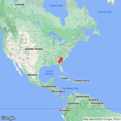
Range: Altamaha River, Georgia, USA. Map of Georeferenced Specimens
 |
Genbank Vouchers
USAUF_437999.013 (COI, ND1, ITS1, 5.8S, 18S) USA, South Carolina, Allendale County, Savannah River, just above mouth of King Creek (The Gaul on some maps) near RM 109.3 (32.87424, -81.45353) UF_437999.011 (COI, ND1, ITS1, 5.8S, 18S) USA, South Carolina, Allendale County, Savannah River, just above mouth of King Creek (The Gaul on some maps) near RM 109.3 (32.87424, -81.45353) UF_437999.015 (COI, ND1, ITS1, 5.8S, 18S) USA, South Carolina, Allendale County, Savannah River, just above mouth of King Creek (The Gaul on some maps) near RM 109.3 (32.87424, -81.45353) UF_438007.016 (COI, ND1, ITS1, 5.8S, 18S) USA, South Carolina, Allendale County, Savannah River, just below Cohens Bluff, RM 103.9, about 11 mi. W of Luray (32.84069, -81.42567) UF_438450.001 (COI, ND1, ITS1, 5.8S, 18S) USA, Georgia, Long/Wayne County, Altamaha River at mouth of Floyds Slough, about 2.5 river km upstream of US 301 bridge (31.677931, -81.846881) UF_437999.014 (COI, ND1, ITS1, 5.8S, 18S) USA, South Carolina, Allendale County, Savannah River, just above mouth of King Creek (The Gaul on some maps) near RM 109.3 (32.87424, -81.45353) UF_437994.009 (COI, ND1, ITS1, 5.8S, 18S) USA, Georgia, Effingham County, Savannah River at base of bluff at mouth of Kennedy Lake (32.4984, -81.23404) UF_439049.9032 (COI, ITS1, 5.8S, 18S) USA, Georgia, Effingham County, Savannah River at RM 54.1, about 4.2 mi. ESE of Clyo (32.46654, -81.19842) UF_437999.010 (COI, ITS1, 5.8S, 18S) USA, South Carolina, Allendale County, Savannah River, just above mouth of King Creek (The Gaul on some maps) near RM 109.3 (32.87424, -81.45353) UF_438439.004 (COI, ITS1, 5.8S, 18S) USA, Georgia, Wayne County, Altamaha River about 1km upstream of Wayne County boat ramp (31.79494, -81.99959) UF_438439.005 (COI, ITS1, 5.8S, 18S) USA, Georgia, Wayne County, Altamaha River about 1km upstream of Wayne County boat ramp (31.79494, -81.99959) UF_437999.012 (COI, ND1, ITS1) USA, South Carolina, Allendale County, Savannah River, just above mouth of King Creek (The Gaul on some maps) near RM 109.3 (32.87424, -81.45353) UF_438009.017 (COI, ND1, ITS1) USA, South Carolina, Jasper County, Savannah River at lower end of slough at Cutoff 7-A at RM 59.5 (32.51821, -81.2426)
UF_439212.003 (COI, ND1, ITS1, 5.8S, 18S) UF_438352.007 (COI, ND1, ITS1, 5.8S, 18S) UF_438352.006 (COI, ND1, ITS1, 5.8S, 18S) Mp_4287_AarcSav018 (COI, ITS1, 5.8S, 18S) Mp_4287_AarcAlt006 (COI, ITS1, 5.8S, 18S) Mp_4287_AarcAlt005 (COI, ITS1, 5.8S, 18S) Mp_4287_AarcAlt001 (COI, ITS1, 5.8S, 18S) Mp_4287_AarcAlt004 (COI, ITS1, 5.8S, 18S) Mp_4287_AarcAlt003 (COI, ITS1, 5.8S, 18S) Mp_4287_AarcSav009 (COI, ITS1, 5.8S, 18S) Mp_4287_AarcSav011 (COI, ITS1, 5.8S, 18S) Mp_4287_AarcAlt002 (COI, ITS1, 5.8S, 18S) Mp_4287_AarcSav010 (COI, ITS1, 5.8S, 18S) Mp_4287_AarcAlt007 (COI, ITS1, 5.8S, 18S) UF_439212.002 (COI, ITS1, 5.8S, 18S) Mp_4287_AarcSav015 (COI, ITS1, 5.8S, 18S) Mp_4287_AarcSav014 (COI, ITS1, 5.8S, 18S) Mp_4287_AarcSav016 (COI, ITS1, 5.8S, 18S) Mp_4287_AarcSav013 (COI, ITS1, 5.8S, 18S) Mp_4287_AarcSav017 (COI, ITS1) Mp_4287_AarcSav012 (COI, ITS1)
|