|
Bivalvia | Unionoida | Unionoidea | Margaritiferidae | Margaritiferinae | Margaritifera species Margaritifera laevis (Haas, 1910): specimens
11 nominal species as synonyms
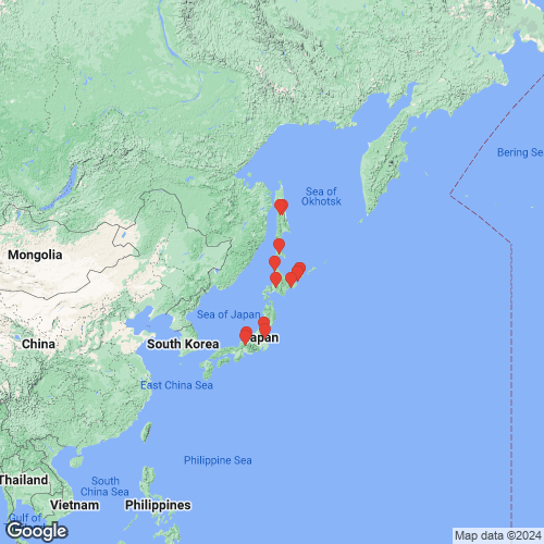
Range: Kuril and Sakhalin islands, Russia and south through Japan. Map of Georeferenced Specimens
 |
Genbank Vouchers
JapanMp_4138_Ma14-2SUTO (COI, 16S, 28S) Gujo, Gifu, Japan Mp_4138_Ma-u2 (COI, 16S, 28S) Teshiogawa River, Hokkaido, Japan Mp_4138_Ma14-1SUTO (COI, 16S) Gujo, Gifu, Japan Mp_4138_Ma14-3SUTO (COI, 16S) Gujo, Gifu, Japan MHS_MMt-tc01 (COI, 28S) Naka River, Tochigi, Japan (36.5875, 140.1013) IDEA_Shell001 (28S) Japan IDEA_Shell002 (28S) Japan
RussiaRMBH_biv_d0082_57 (COI, 16S, 28S, 18S) Tym’ River, Sakhalin Island, Russia (50°54’45” N, 142°39’48” E) RMBH_biv_d0036_22 (COI, 16S, 28S, 18S) Russia: Far East, Kurile Archipelago, Kunashir Island, Sennaya River (43.7489°N, 145.4658°E), Pacific Ocean drainage RMBH_biv_d0082_60 (COI, 18S) Tym’ River, Sakhalin Island, Russia (50°54’45” N, 142°39’48” E) RMBH_biv_d0044_12 (COI, 18S) Golovnina River, Kunashir Island, Kurile Islands, Russia (43°44’57” N, 145°30’25” E) RMBH_biv_d0077_8 (COI, 18S) Lyutoga River, Sakhalin Island, Russia (46°46’29” N, 142°26’21” E) RMBH_biv_d0082_83 (COI, 18S) Tym’ River, Sakhalin Island, Russia (50°54’45” N, 142°39’48” E) RMBH_biv_d0022_19 (COI) Serebryanka River, Kunashir Island, Kurile Islands, Russia (44°03’18” N, 145°51’15” E) RMBH_biv_d0077_36 (COI) Lyutoga River, Sakhalin Island, Russia (46°46’29” N, 142°26’21” E) RMBH_biv_d0036_1 (COI) Sennaya River, Kunashir Island, Kurile Islands, Russia (43°44’56” N, 145°27’57” E) RMBH_biv_d0044_15 (COI) Golovnina River, Kunashir Island, Kurile Islands, Russia (43°44’57” N, 145°30’25” E) RMBH_biv_d0022_21 (COI) Serebryanka River, Kunashir Island, Kurile Islands, Russia (44°03’18” N, 145°51’15” E) RMBH_biv_d0022_17 (COI) Serebryanka River, Kunashir Island, Kurile Islands, Russia (44°03’18” N, 145°51’15” E) RMBH_biv_d0034_27 (COI) Rikorda River, Kunashir Island, Kurile Islands, Russia (43°44’58” N, 145°31’33” E) RMBH_biv_d0077_34 (COI) Lyutoga River, Sakhalin Island, Russia (46°46’29” N, 142°26’21” E) RMBH_biv_d0034_28 (COI) Rikorda River, Kunashir Island, Kurile Islands, Russia (43°44’58” N, 145°31’33” E) RMBH_biv_d0034_29 (COI) Rikorda River, Kunashir Island, Kurile Islands, Russia (43°44’58” N, 145°31’33” E) RMBH_biv_d0036_23 (COI) Sennaya River, Kunashir Island, Kurile Islands, Russia (43°44’56” N, 145°27’57” E) RMBH_biv_d0044_13 (COI) Golovnina River, Kunashir Island, Kurile Islands, Russia (43°44’57” N, 145°30’25” E)
MNCN_FW1502-2 (COI, 16S, 28S, 18S, H3) MNCN_FW1502-3 (COI, 16S, 28S, 18S, H3) MNCN_FW1502-1 (COI, 16S, 28S, 18S, H3) 20 - MMt-tc01 (mtGenome) ML18001 (28S) ML14081 (28S)
|