|
Unionoida | Hyrioidea | Hyriidae | Hyriinae | Hyridellini | Hyridella species Hyridella drapeta (Iredale, 1934): specimens
5 nominal species as synonyms
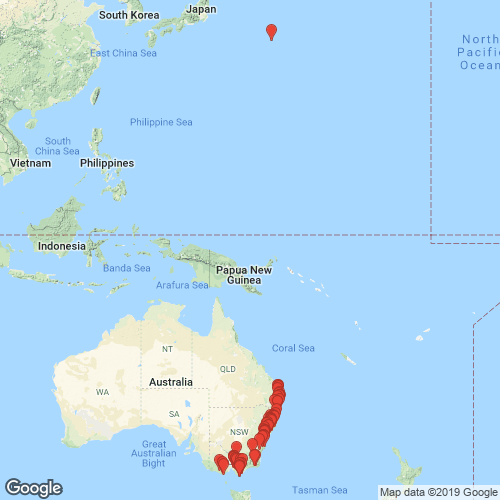
Range: Queensland south to Victoria, eastern Australia. Map of Georeferenced Specimens
 |
Australia |

ZMB_MP_0431
Australia
|

ZMB_MP_0433
Australia
|

ZMB_19078
Richmond River, NS Wales
|

ZMB_MP_0442
Upper Richmond River, New Holland
|

BMNH_MP_098
Moreton Bay
|

AMS_126300
Blaxlands Dam, Nepean River, New South Wales, Australia [-33.85, 150.633 ± 1 km]
|

AMNH_46663
Evelyn, Victoria
|

BMNH_91-11-6-106
Australia
|

UMMZ_304506
Karuah River, Monkerai, New South Wales, Australia
|

UMMZ_304505
Glochester River, Doon Ayre, New South Wales, Australia, -31.89607°, 152.08942°
|

UA_20811
Glochester River, Doon Ayre, New South Wales, Australia, -31.89607°, 152.08942°
|

UA_20808
Mammy Johnson River, 10 km E Wards River, New South Wales, Australia, -32.24361°, 151.97556°
|

BMNH_MP_113
Olinda, Victoria, Australia
|

DMNH_146481
Victoria, Australia
|

AMS_126404
Woronora River, S of Sydney, New South Wales, Australia [-34.065, 150.995 ± 10 km]
|

DMNH_172989
Olinda Creek, Evelyn, Victoria, Australia
|

DMNH_172995
Olinda Creek, Evelyn, Victoria, Australia
|

DMNH_78614
creek near Cungai, New South Wales, Australia
|

AMS_126336
Warrel Creek at Eungai, New South Wales, Australia [-30.853, 152.898 ± 1 km]
|

HYR001
Watagan Creek
|

HYR002
Watagan Creek
|

HYR003
Karuah River at Booral
|

HYR006
Karuah River at Booral
|

HYR009
Williams River at Thalaba
|

HYR010
Williams River at Thalaba
|

HYR011
Williams River at Thalaba
|

HYR012
Karuah River at Monkerai
|

AMS_126366
Warrel Creek at Eungai, New South Wales, Australia [-30.853, 152.898 ± 1 km]
|

AMS_61939
Clarence River at Tucabia (Permanent waterhole in swamp area), New South Wales, Australia [-29.672, 153.092 ± 10 km]
|

AMS_61945
Byron Bay, Broken Head, Bangalow Creek, New South Wales, Australia [-28.717, 153.608 ± 1 km]
|

AMS_128071
Lake Eucumbene, Poplars, New South Wales, Australia [-36.05, 148.7 ± 10 km]
|

AMS_126129
Barrengarry Creek, Kangaroo Valley, New South Wales, Australia [-34.683, 150.55 ± 10 km]
|

AMS_126149
Allyn River at Eccleston, New South Wales, Australia [-32.269, 151.489 ± 1 km]
|

AMS_62153
Shoalhaven River, Gordon Barrier, New South Wales, Australia [-34.883, 150.458 ± 10 km]
|

AMS_61943
Stroud Creek, Stroud, New South Wales, Australia [-32.408, 151.967 ± 100 km]
|

AMNH_305992
Lansdown River, 14 m. from “Larce”, New South Wales, Australia
|

AMS_332159
between Longflat & Wauchope, Hastings River, New South Wales, Australia [-31.467, 152.617 ± 10 km]
|

AMS_126374
Bex Hill NE of Lismore, New South Wales, Australia [-28.766, 153.346 ± 1 km]
|

AMS_61940
Manning River, Mount George, New South Wales, Australia [-31.886, 152.167 ± 1 km]
|

AMS_105918
Mongarlowe River, Charleyong, New South Wales, Australia [-35.253, 149.919 ± 1 km]
|

AMS_173135
NNW of Nowra, Kangaroo Valley, New South Wales, Australia [-34.737, 150.533 ± 10 km]
|

AMS_61937
Richmond R trib., Wilsons R, Booyong, Pearces Ck, New South Wales, Australia [-28.75, 153.448 ± 1 km]
|

AMS_126294
Manning River at Mount George, New South Wales, Australia [-31.888, 152.167 ± 1 km]
|

AMS_332170
Williams River at Dungog, New South Wales, Australia [-32.398, 151.763 ± 10 km]
|

AMS_61942
Warrel Creek at Eungai, New South Wales, Australia [-30.853, 152.898 ± 1 km]
|

AMS_174667
Creek off Wollombi River off Cessnock Road (Trails in sand), New South Wales, Australia [-32.883, 151.183 ± 10 km]
|

AMS_61941
Hawkesbury River at Richmond, New South Wales, Australia [-33.587, 150.723 ± 10 km]
|

AMS_61947
Mt Evelyn (Creek), Victoria, Australia [-37.783, 145.383 ± 10 km]
|

AMS_80636
Upper Manning River, N of Rookhurst, N of Gloucester (On bank), New South Wales, Australia [-31.866, 151.861 ± 10 km]
|

AMS_61946
Manning R, Wingham, New South Wales, Australia [-31.876, 152.369 ± 1 km]
|

AMS_132197
SW Tuggerah Lakes, New South Wales, Australia [-33.333, 151.467 ± 10 km]
|

AMS_126309
Richmond River, New South Wales, Australia [-28.867, 153.05 ± 100 km]
|

AMS_159164
Gauge Station 100m east of Rd bridge over Mt Emu Ck (Under rocks & in silt at base of rushes), Victoria, Australia [-38.307, 142.887 ± 1 km]
|

AMS_62023
Tarra River at Port Albert, Victoria, Australia [-38.65, 146.717 ± 10 km]
|

AMS_158404
Calder R, 25m upstream from Great Ocean Rd bridge (In silt, at river edge), Victoria, Australia [-38.774, 143.508 ± 1 km]
|

AMS_168579
Franklin R, at Princes Hwy, E of Foster (River bank), Victoria, Australia [-38.655, 146.296 ± 1 km]
|

AMS_61935
Brisbane River, Queensland, Australia [-27.583, 152.917 ± 100 km]
|

AMS_62013
Bunyip River, Victoria, Australia [-37.917, 145.717 > ± 100 km]
|

AMS_62021
Wilsons Prom, Sealers Ck, Victoria, Australia [-39.017, 146.383 ± 10 km]
|

AMS_61948
Lilydale, Victoria, Australia [-37.767, 145.35 ± 10 km]
|

AMS_61932
Tomahawk Creek, Gembrook, Dandenong Ranges, Victoria, Australia [-37.95, 145.55 ± 10 km]
|

AMS_110183
Tonghi Ck, 5 miles W of Cann River, Victoria, Australia [-37.567, 149.061 ± 1 km]
|

AMS_62020
Tarra River at Tarraville, Victoria, Australia [-38.633, 146.717 ± 10 km]
|

AMS_61933
Richmond River, New South Wales, Australia [-28.867, 153.05 ± 100 km]
|

AMS_110532
Tonghi Ck, 5 miles W of Cann River, Victoria, Australia [-37.567, 149.061 ± 1 km]
|

AMS_61944
Cann River at Cann River township, Victoria, Australia [-37.567, 149.15 ± 10 km]
|

AMS_126127
North Pine River (In scrub), Queensland, Australia [-27.283, 153.067 ± 100 km]
|

AMS_381800
Brisbane, The Blunder, Blunder Ck, Queensland, Australia [-27.617, 152.983 ± 10 km]
|

AMS_57938
Tarra River at Tarraville, Victoria, Australia [-38.633, 146.717 ± 10 km]
|

AMS_62016
Glengarry, Victoria, Australia [-38.133, 146.583 ± 10 km]
|

AMS_62018
Broken R. at Nalinga, Victoria, Australia [-36.433, 145.733 ± 10 km]
|

AMS_168578
Wilsons Prom. NP, Growler Ck, at bridge (In mud under bridge), Victoria, Australia [-39.063, 146.374 ± 100 m]
|

AMS_126107B
North Pine River, Queensland; 27°15’S, 152°54’E
|

UMMZ_111817
Clarence River, New South Wales, Australia
|

UMMZ_111818
Brisbane Water, Australia
|

USNM_853937
Tweed River, near Mt. Warning, New South Wales, Australia
|

UMMZ_111830
Queensland, Australia
|

MCZ_110403
Cann River, Cann River Town, North Victoria, Australia
|

UMMZ_111832
Richmond River, New South Wales, Australia
|

MCZ_190259
Sealers Creek, Wilson’s Promontory, Victoria, Australia
|

MCZ_190258
Manning River, Mount George, New South Wales, Australia
|

MCZ_210898
Pearce’s Creek, Booyong, Richmond R., New South Wales, Australia
|

MCZ_190257
Manning River, Wingham, New South Wales, Australia
|

MCZ_190256
Warrel Creek, trib. of Nambucca River System, Eungai, New South Wales, Australia
|

USNM_40866
Richmond River, N.S. Wales, Australia
|

USNM_170109
New South Wales, Australia
|

USNM_623353
North Pine R., vicinity of Brisbane, Queensland, Australia
|

USNM_339720
Richmond R., New South Wales, Australia
|

MNHN_MP_1480
Cann River, S. Australia
|

FMNH_115955
Cann River, North Victoria, Australia
|

FMNH_190535
near Eungai, north coast of New South Wales, Australia
|

FMNH_21735
Watson’s Creek, Victoria, Australia
|

FMNH_77366
Evelyn, Victoria, Australia
|

MNHN_MP_1479
New South Wales
|

AMS_411606
Diamond Ck (?), Bunyip State Park (On roots, leaves, etc), Victoria, Australia [-37.985, 145.643 ± 100 m]
|

AMS_61931
Tomahawk Creek, Gembrook, Dandenong Ranges, Victoria, Australia [-37.95, 145.55 ± 10 km]
|

AMS_61936
Latrobe River, Gippsland, Victoria, Australia [-38.15, 146.783 ± 100 km]
|

MNHN_MP_1481
New South Wales
|

AMS_61938
Clarence River at Tucabia (Permanent waterhole in swamp area), New South Wales, Australia [-29.672, 153.092 ± 10 km]
|

AMS_61934
Brisbane River, Queensland, Australia [-27.583, 152.917 ± 100 km]
|

BMNH_85-3-17-13-15
creek, Bulu Bulu, Gippsland, Victoria
|

BMNH_91-11-6-198-199
Richmond River, NSW
|

BMNH_91-11-6-190-195
Richmond River, NSW
|

BMNH_91-11-6-196-197
Richmond River, NSW
|

BMNH_89-10-25-11-23
Shoalhaven River
|

BMNH_89-10-25-27-28
Wyong Creek
|
|
|
|
AMS_173164 Dunbible Creek, Murwillumbah, New South Wales, Australia [-28.352, 153.393 ± 10 km]
AMS_421938 Dungog, Williams R between railway bridge and rd bridge beside park, New South Wales, Australia [-32.397, 151.762 ± 100 m]
AMS_173159 Eungai, New South Wales, Australia [-30.835, 152.893 ± 10 km]
AMS_432169 Hunter Region, Williams R at Bandon Grove Park, Chichester Dam rd crossing nr bank (Moderate flow, gravelly/rock bottom), New South Wales, Australia [-32.301, 151.719 ± 100 m]
AMS_424072 Lake Eucumbene, Poplars, New South Wales, Australia [-36.05, 148.7 ± 10 km]
AMS_424073 Manning R, Wingham, New South Wales, Australia [-31.876, 152.369 ± 1 km]
AMS_173158 Mill Creek, Stroud, New South Wales, Australia [-32.411, 151.959 ± 10 km]
AMS_431976 Millers Ck, on Bunkers Hill Rd, trib of Barrengary Ck, New South Wales, Australia [-34.683, 150.53 ± 1 km]
AMS_174666 Nepean River at Douglas Park (In sandy mud), New South Wales, Australia [-34.194, 150.712 ± 10 km]
AMS_174669 Nepean River, Camden, New South Wales, Australia [-34.073, 150.699 ± 10 km]
AMS_422341 Sandy Ck, at Gellibrand R rd bridge, SW of Carlisle R (In mud), Victoria, Australia [-38.591, 143.354 ± 1 km]
AMS_358673 Tucabia via Ulmarra, Carence River district, New South Wales, Australia [-29.667, 153.1 ± 10 km]
AMS_173154 Tucabia via Ulmarra, New South Wales, Australia [-29.667, 153.1 ± 10 km]
AMS_332476 Williams River, Dungog (In mud), New South Wales, Australia [-32.398, 151.763 ± 10 km]
AMS_422340 Wilsons Prom, Growler Ck, at rd bridge (=EV25) (In mud, roots & debris on ck bed), Victoria, Australia [-39.063, 146.374 ± 1 km]
AMS_424071 Wollombi, New South Wales, Australia [-32.933, 151.15 ± 10 km]
AMS_126345 Woronora River near Engadine, New South Wales, Australia [-34.065, 150.995 ± 10 km]
AMS_173132 Woronora River near Engadine, New South Wales, Australia [-34.065, 150.995 ± 10 km]
AMS_174787 near Cessnock, W of Milfield, Wollombi Rd, Wollombi Brook N Arm, at Cedar Rd crossing, New South Wales, Australia [-32.937, 151.14 ± 1 km]
|
Genbank Vouchers
UMMZ_304506 (COI, 16S, 28S) UMMZ_304505 (COI, 16S, 28S)
|