|
Bivalvia | Sphaerioida | Sphaerioidea | Sphaeriidae | Sphaeriinae | Odhneripisidium species Odhneripisidium stewarti (Preston, 1909): specimens
4 nominal species as synonyms
Taxonomic History (since 2007)
Pisidium stewarti — Bogan (2010), IUCN (2011), Clewing et al. (2013), He & Zhuang (2013), Bolotov et al. (2015), Bößneck et al. (2016), Clewing et al. (2020), Saito et al. (2022), Clewing et al. (2022)
Odhneripisidium stewarti — Kantor et al. (2010), Bespalaya et al. (2023)
Odhneripisidium prashadi — Kantor et al. (2010)
Odhneripisidium kungejense — Kantor et al. (2010)
Pisidium (Odhneripisidium) stewarti — Vinarski & Kantor (2016), Bespalaya et al. (2017)
Pisidium (Odhneripisidium) prashadi — Vinarski & Kantor (2016)
Pisidium (Odhneripisidium) kungejense — Vinarski & Kantor (2016)
|
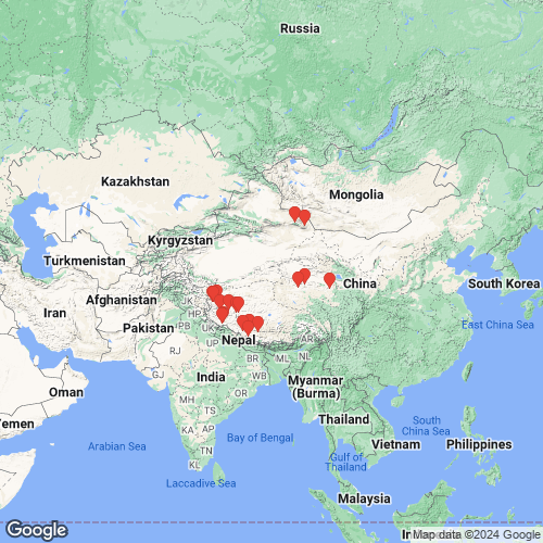
Range: Central Asia and Tibet. Map of Georeferenced Specimens
 |
There are no specimens in the MUSSELpdb for this species.
Genbank Vouchers
ChinaUGSB_9089 (CN15/1) (COI, 16S, 28S, H3) China, Qinghai, Donggi Cona (35.28861° 98.70116°) UGSB_9090 (CN15/2) (COI, 16S, 28S) China, Qinghai, Donggi Cona (35.28861° 98.70116°) UGSB_9998 (CN06/3) (COI, 16S) China, Tibet, pond near Lazangxiang (29.50262° 84.57673°) UGSB_9990 (CN02/3) (COI, 16S) China, Tibet, small river south of Golmud (35.43374° 93.60115°) UGSB_9988 (CN02/2) (COI, 16S) China, Tibet, small river south of Golmud (35.43374° 93.60115°) UGSB_10990 (CN19/1) (16S, 28S) China, Tibet, inflow Bangong Co (33.66933° 80.46586°) UGSB_10991 (CN20/1) (16S, 28S) China, Tibet, dam region near Bangong Co (33.56812° 79.94763°) UGSB_10001 (CN07/6) (COI, 16S) China, Tibet, Lake Manasarovar (30.60952° 81.36448°) UGSB_10007 (CN16/2) (COI, 16S) China, Tibet, river west of Ge’gyai (32.45972° 80.89935°) UGSB_10002 (CN07/7) (COI, 16S) China, Tibet, Lake Manasarovar (30.60952° 81.36448°) UGSB_10006 (CN16/1) (COI, 16S) China, Tibet, river west of Ge’gyai (32.45972°N, 80.89935°E) RMBH_MSph_332 (16S, 28S) China: Xinjiang, Yiwu County, Stream near Torkel lake UGSB_9992 (CN03/4) (COI, 16S) China, Tibet, wetlands west of Ngamring Co (29.34203° 87.16489°) UGSB_9995 (CN04/2) (COI, 16S) China, Tibet, wetlands near Paiku Co (28.77180° 85.56133°) UGSB_10003 (CN08/4) (COI, 16S) China, Tibet, spring complex north of Lake Manasarovar (30.81483° 81.56236°) UGSB_10992 (CN20/2) (COI, 16S) China, Tibet, dam region near Bangong Co (33.56812° 79.94763°) RMBH_MSph_323 (16S, 28S) China: Xinjiang, Barkol Kazakh Autonomous County, Stream on the shore of Lake Barkul UGSB_10987 (CN17/1) (16S, 28S) China, Tibet, river near Nam Co (33.62711°N, 79.77509°E) UGSB_9997 (CN06/2) (COI, 16S) China, Tibet, pond near Lazangxiang (29.50262° 84.57673°) UGSB_8391 (CN01/1) (16S) China, Tibet, pond south of Golmud (35.88329° 94.57995°) UGSB_8388 (CN13/1) (16S) China, Tibet, Dajiamang Co (29.63267° 85.74019°) UGSB_8405 (CN07/2) (16S) China, Tibet, Lake Manasarovar (30.60952° 81.36448°) UGSB_8409 (CN08/1) (16S) China, Tibet, spring complex north of Lake Manasarovar (30.81483° 81.56236°) UGSB_8398 (CN04/1) (16S) China, Tibet, wetlands near Paiku Co (28.77180° 85.56133°) UGSB_8410 (CN08/2) (16S) China, Tibet, spring complex north of Lake Manasarovar (30.81483° 81.56236°) UGSB_8404 (CN07/1) (16S) China, Tibet, Lake Manasarovar (30.60952° 81.36448°) UGSB_8383 (CN11/1) (16S) China, Tibet, wetlands south of Gerze (32.06443° 83.90559°) UGSB_8384 (CN12/1) (16S) China, Tibet, wetlands west of Cakaxiang (32.44139° 82.43805°) UGSB_8403 (CN06/1) (16S) China, Tibet, pond near Lazangxiang (29.50262° 84.57673°) UGSB_8377 (CN09/2) (16S) China, Tibet, pond near Cam Co (32.08300° 83.66180°) UGSB_8396 (CN03/3) (16S) China, Tibet, wetlands west of Ngamring Co (29.34203° 87.16489°) UGSB_8376 (CN09/1) (16S) China, Tibet, pond near Cam Co (32.08300° 83.66180°) UGSB_8392 (CN02/1) (16S) China, Tibet, small river south of Golmud (35.43374° 93.60115°)
|