|
Unionoidea | Unionidae | Gonideinae | Pseudodontini | Pseudodontina | Bineurus species Bineurus mouhotii (Lea, 1863): specimens
4 nominal species as synonyms
Taxonomic History (since 2007)
Pseudodon (Bineurus) mouhotii — Graf & Cummings (2007)
Pseudodon mouhotii — Bogan (2010), IUCN (2012), He & Zhuang (2013), Pfeiffer & Graf (2015), Kongim et al. (2015), Lopes-Lima et al. (2017), Konopleva et al. (2017), Do et al. (2018), Zieritz et al. (2018)
Pseudodon aff. mouhotii sp. 1 — Bolotov et al. (2017)
Bineurus aff. mouhotii sp. 1 — Bolotov et al. (2017), Bolotov et al. (2018), Huang et al. (2019), Konopleva et al. (2019), Lopes-Lima et al. (2020)
Pseudodon aff. mouhotii sp. 2 — Bolotov et al. (2017)
Pseudodon aff. mouhotii sp. 3 — Bolotov et al. (2017)
Bineurus aff. mouhotii sp. 2 — Bolotov et al. (2017), Bolotov et al. (2018), Huang et al. (2019), Konopleva et al. (2019)
Bineurus aff. mouhotii sp. 3 — Bolotov et al. (2017), Bolotov et al. (2018), Huang et al. (2019), Konopleva et al. (2019)
Bineurus mouhotii — Konopleva et al. (2019), Pfeiffer et al. (2019), Bolotov et al. (2020), Ng et al. (2020), ..., Dai et al. (2024), Jeratthitikul et al. (2025), Dai et al. (2025), Konopleva et al. (2025)
|
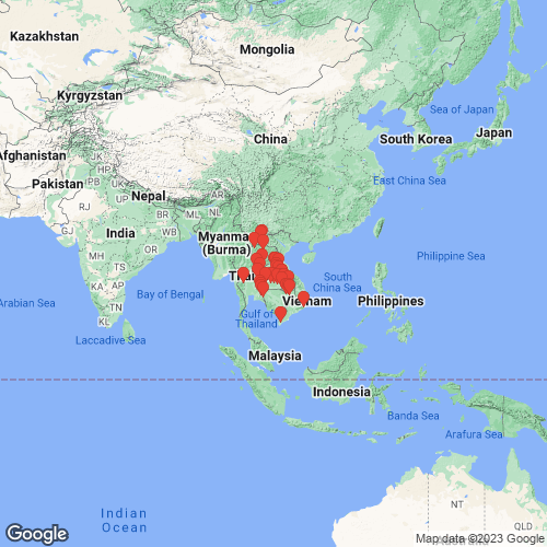
Range: Thailand, Laos, Cambodia and Vietnam, and north into China. Map of Georeferenced Specimens
 |
Cambodia |

FMNH_21809
Laos Mountains, Cambodia
|

MCZ_175549
Laos Mtns., Cambodia, French Indo-China
|

BMNH_MP_D010
Lao Mountains, Camboja
|

ANSP_125808
Rivers in Laos Mountains, Cambodia
|

USNM_86339
Laos Mts., Cambodia, Siam
|

UF_507896
Tonle Kong River just upstream of island, 8.3 miles NE of AH11 bridge near Stung Treng. CA16-04. 13.609383 106.092445
|

UF_507381
Tonle Srepok River, major bridge crossing on road from Stung Treng to Ban Lung. Srae Angkrorng, Ratanakiri, Cambodia. CA16-01. 13.44339, 106.60329
|

UF_507387
Tonle Srepok River, bridge just north of Phumi Srê Ta Chan, Cambodia. CA16-02. 13.50248, 106.35194
|

UF_507391
Tonle Sekong River, 1.6 miles upstream from AH11 Bridge. CA16-03. 13.54504, 106.01353
|
Indonesia |

ANSP_125807
Sumatra
|
|
|
Laos |

MNHN_MP_3194
Laos: Sedone River at Pakse
|

MNHN_MP_3612
Ban Nam Nga, Haut Laos
|

SMF_319321
Laos: Mekong at Pakse
|

NCSM_84900
Asia, Mekong Basin/Mekong R. Laos, Khammouan, Thakhek Co. Houay Karnbeung, small stream arising at cave near Ban Khounephavang [Kouanphavang], Nam Done drainage, 14 [air] km from Thakhek road to Gnommalath, [0.92 air miles WNW center Xianliab]. 17.45781° N, 104.9263° E
|

NCSM_84901
Asia, Mekong Basin/Mekong R. Laos, Khammouan, Thakhek Co. Houay Karnbeung, small stream arising at cave near Ban Khounephavang [Kouanphavang], Nam Done drainage, 14 [air] km from Thakhek road to Gnommalath, [0.92 air miles WNW center Xianliab]. 17.45781° N, 104.9263° E
|

UA_20996
Houai Pin, about 300 m upstream of mouth, ca. 4 km..., Attapeu Province, Laos. 14.67944, 106.48417
|

SMF_205129
Laos: Mekong at Monlapanuk
|
|
|
Thailand |

MNHN_MP_3197
Huai Gaeng Yang, Pibun Mangsahan, Chong Mek, Ubon Province, Thailand
|

BMNH_MP_D009
Huai Gaeng Yang, Pibun Mangsahan, Ubon Province, Thailand
|

SMF_319316
Klong Satung, Srakeo, Prov Prachinburi
|

SMF_319317
Thailand: Mun river near Ban Tha Tum
|

USNM_127196
Siam
|

SMF_319318
Thailand: Huai Ka Yung, Prov. Ubon
|

SMF_319320
Maenam Phong near Ban Pha Nog Kao; Phugradung; Loei
|

UF_507816
Bang Sai River at Rt. 2292 bridge. TH16-44. 16.737, 104.520
|

ANSP_331313
Huai Kwang, Amphoe Phibun Mangsahan, Ubon Ratchathani Prov., Thailand
|

ANSP_331315
Huai Kwang, Amphoe Phibun Mangsahan, Ubon Ratchathani Prov., Thailand
|

UF_507828
Bang River at Rt. 2034 bridge approx. 5 km NW of intersection with Rt. 2277. TH16-47. 16.346, 104.883
|

ANSP_41769
Siam
|

UF_507835
Bang River at Rt. 212 bridge approx. 5 km N of Ban Nikhom Kham Soi. TH16-49. 16.395934, 104.571480
|

UF_346491
Thailand, Uthai Thani Province, Huai Kha Khaeng Reserve, Huai Mae Di River, 15.2758°, 99.1553°
|

UF_507845
Sa Thung River at Rt. 2112 bridge approx. 15 km SE of intersection with Rt. 2337. TH16-52. 15.730746, 105.451129
|

UF_507846
Ta Wang River at Rt. 2112 bridge approx. 4 km SSE of intersection with Rt. 2337. TH16-53. 15.792920, 105.376142
|

UF_507854
Dom Noi River off Rt. 2248 approx. 8.5 km S of Buntharik, TH16-58, 14.686046, 105.383334
|

INHS_25290
trib. Khlong Phra Phong, 20 km E Khlong Hat, Hwy. 3259, Sakaeo, Thailand
|

UF_507856
Dom Noi River off Rt. 2248 approx. 8.5 km S of Buntharik. TH16-58. 14.686046, 105.383334
|

SMF_220900
Thailand: Huai Glaeung Yang, Pibun mangashan-Chon Mek, Ubon
|

SMF_220901
Mun River, Rasi Salai
|

ANSP_H19064
Huai Gaeng Yang, Pibun Mangsahan, Chong Mek, Ubon Province, Thailand
|

UF_507476
Plai Mat River off HWY 2226/2175 in Tha Lat. JMP17-34. 15.28664, 102.68528
|

UF_426972-02
Thailand, Samrong Province, 3 km E on Lao Ngam, 15.7472°, 105.4504°
|

UF_435017
Thailand, Uthai Thani Province, Huai Kha Khaeng Reserve, Huai Kha Khaeng River, 15.2758°, 99.1553°
|

NCSM_43470
Asia, Mekong Basin/Mekong R. Thailand, Surin, [Unknown body of water], not far from Mekong River, Northeast Thailand, not too far from Cambodia border, [point estimated at Khong Chiam] 15.6° N, 105.6° E
|

UF_507494
Chiang River at Rt. 2359 in Tham Wua Daeng. JMP17-40. 16.01742, 101.50558
|

SMF_188794
Ban gaeng Hai; Loei Prov. Nam San Dan Sai
|

UF_507756
Trib. of Mekong River at Rt. 211 bridge approx. 3 km S of Ban Muang. TH16-28. 18.151, 102.179
|

UF_507639
Songkhram River at confluence with Mao River. TH15-11. 17.70202, 104.25579
|

UMMZ_23127
Siam
|

SMF_5941
Thailand: Huai Glaeng Yang Pibun Mangsahan; Chong Mek, Ubon Province
|

UF_507644
Songkhram River at confluence with Yam River. TH15-12. 17.70906, 104.07671
|

UF_507544
Sai Khao River at Rt. 3193 in Sai Khao. JMP17-55. 13.06194, 102.32694
|

UF_507530
Yang River at Rt. 3004 in Na Di. JMP17-50. 14.13651, 101.85750
|
|
Vietnam |

FMNH_21810
Annam
|

BMNH_1901-12-12-95-99
Sud Annam, Pha-Rang
|

ANSP_336865
in rice fields near Mekong River, Caisan Dist., Anxuyen Prov., [now Ca Mau Province], South Vietnam
|

UMMZ_110257
Phan Rang, Southern Annam, French Indo China
|

BMNH_1903-5-22-18-19
Tonkin
|
|
Genbank Vouchers
LaosRMBH_biv_183_4 (COI, 16S, 28S) Laos: Mekong River basin, Nam Long River RMBH_biv_201_2 (COI, 16S, 28S) Laos: Mekong River basin, a tributary of Nam Fa River near Vieng Phou Kha RMBH_biv_182_2 (COI, 16S, 28S) Laos: Mekong River basin, Nam Long River RMBH_biv_201_3 (COI, 16S, 28S) Laos: Mekong River basin, a tributary of Nam Fa River near Vieng Phou Kha RMBH_biv_201_5 (COI, 16S, 28S) Laos: Mekong River basin, a tributary of Nam Fa River near Vieng Phou Kha RMBH_biv_182_19 (COI, 16S, 28S) Laos: Mekong River basin, Nam Long River RMBH_biv_202_1 (COI, 28S) Laos: Mekong River basin, a tributary of Nam Fa River near Vieng Phou Kha RMBH_biv_201_1 (16S) Laos: Mekong River basin, a tributary of Nam Fa River near Vieng Phou Kha
ThailandUF_507756 (ICH-00733) (COI) Thailand, Trib. of Mekong River at Rt. 211 bridge approx. 3 km S of Ban Muang (18.15107, 102.178987) UF_507756 (ICH-00735) (COI) Thailand, Trib. of Mekong River at Rt. 211 bridge approx. 3 km S of Ban Muang (18.15107, 102.178987)
|