|
Unionoidea | Unionidae | Gonideinae | Pseudodontini | Pseudodontina | Bineurus species Bineurus exilis (Morelet, 1866): specimens
3 nominal species as synonyms
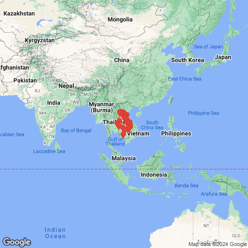
Range: Mekong River, Thailand and Laos. Map of Georeferenced Specimens
 |
Cambodia |

UF_507440
Tributary of Tonle Sap River, HWY 5 bridge south of Rolea B'ier District. CA16-12. 12.18893, 104.66102
|

MNHN_MP_0103
Cochinchine, Kampot
|

UF_507413
Unknown tributary of Mekong just N of Phumi Prêk Krieng on AH11. CA16-07. 13.04014, 106.18086
|

BMNH_93-2-4-1981
Lac Tonli-Sap Cambodia
|

MNHN_MP_3188
Kampot
|

MNHN_MP_3224
Sombor
|
Indonesia |

UMMZ_110253
Java, Dutch East Indies
|
|
|
Laos |

NCSM_84903
Asia, Mekong Basin/Bang Fai R. Laos, Khammouan, Mahaxay Co. Nam Oula, near Ban Phonexay, [2.93 air miles NNW center Ban Sang Phoc]. 17.36628° N, 105.3511° E
|

UMMZ_304649
Houai Pin, about 300 m upstream of mouth, ca. 4 km..., Attapeu Province, Laos. 14.7944, 106.48417
|
|
Thailand |

MNHN_MP_3186
riv. de Sutrang (Siam)
|
|
|
unknown |

MNHN_MP_3195
Mekong
|
|
|
Genbank Vouchers
CambodiaUF_507381 (ICH-00412) (COI) Cambodia, Tonle Srepok River, major bridge crossing on road from Stung Treng to Ban Lung (13.443388, 106.603294) UF_507381 (ICH-00423) (COI) Cambodia, Tonle Srepok River, major bridge crossing on road from Stung Treng to Ban Lung (13.443388, 106.603294) UF_507381 (ICH-00422) (COI) Cambodia, Tonle Srepok River, major bridge crossing on road from Stung Treng to Ban Lung (13.443388, 106.603294) UF_507413 (ICH-00538) (COI) Cambodia, Unknown tributary of Mekong just N of Phumi Prêk Krieng on AH11 (13.040143, 106.180864) UF_507440 (ICH-00611) (COI) Thailand, Tributary of Tonle Sap River, HWY 5 bridge south of Rolea B'ier District (12.188929, 104.661024) UF_507413 (ICH-00540) (COI) Cambodia, Unknown tributary of Mekong just N of Phumi Prêk Krieng on AH11 (13.040143, 106.180864) UF_507440 (ICH-00609) (COI) Thailand, Tributary of Tonle Sap River, HWY 5 bridge south of Rolea B'ier District (12.188929, 104.661024) UF_507440 (ICH-00610) (COI) Thailand, Tributary of Tonle Sap River, HWY 5 bridge south of Rolea B'ier District (12.188929, 104.661024) UF_507413 (ICH-00539) (COI) Cambodia, Unknown tributary of Mekong just N of Phumi Prêk Krieng on AH11 (13.040143, 106.180864)
LaosUMMZ_304649 (COI, 16S, 28S) Houai Pin, about 300 m upstream of mouth, ca. 4 km..., Attapeu Province, Laos. 14.7944, 106.48417 RMBH_biv_871_2 (COI, 16S, 28S) Laos: Phaphou Stream, Mekong River basin (14.727609, 106.093295) RMBH_biv_871_1 (COI, 16S, 28S) Laos: Phaphou Stream, Mekong River basin (14.727609, 106.093295) RMBH_biv_818_3 (COI, 16S, 28S) Laos: Nam Leuk River, Mekong River basin (18.3952, 103.149439) RMBH_biv_887_3 (COI, 16S, 28S) Laos: Bag Liang River, Mekong River basin (14.9789751, 105.9171379) NCSM_84903 (COI, 28S) Asia, Mekong Basin/Bang Fai R. Laos, Khammouan, Mahaxay Co. Nam Oula, near Ban Phonexay, 17.36628° N, 105.3511° E RMBH_biv_880_2 (COI) Laos: Tomotha Stream, Mekong River basin (14.8075, 105.9194) RMBH_biv_883_3 (COI) Laos: Huay Tuay River, Mekong River basin (14.8732134, 105.9339) RMBH_biv_818_2 (COI) Laos: Nam Leuk River, Mekong River basin (18.3952, 103.149439) RMBH_biv_847_2 (COI) Laos: Nam Sone River, Mekong River basin (17.2535051, 105.1059142) RMBH_biv_814_1 (COI) Laos: Nam Ngum River, Mekong River basin (18.212349, 102.999821) RMBH_biv_887_1 (COI) Laos: Bag Liang River, Mekong River basin (14.9789751, 105.9171379) RMBH_biv_818_1 (COI) Laos: Nam Leuk River, Mekong River basin (18.3952, 103.149439) RMBH_biv_857_2 (COI) Laos: Nam Don River, Mekong River basin (17.4781121, 104.7629659) RMBH_biv_855_1 (COI) Laos: Nam Don River, Mekong River basin (17.4781121, 104.7629659) RMBH_biv_880_1 (COI) Laos: Tomotha Stream, Mekong River basin (14.8075, 105.9194) RMBH_biv_847_3 (COI) Laos: Nam Sone River, Mekong River basin (17.2535051, 105.1059142) RMBH_biv_857_1 (COI) Laos: Nam Don River, Mekong River basin (17.4781121, 104.7629659) RMBH_biv_835_3 (COI) Laos: Nam Deua Stream, Mekong River basin (18.222894, 104.198668) RMBH_biv_887_2 (COI) Laos: Bag Liang River, Mekong River basin (14.9789751, 105.9171379) RMBH_biv_883_2 (COI) Laos: Huay Tuay River, Mekong River basin (14.8732134, 105.9339) RMBH_biv_857_3 (COI) Laos: Nam Don River, Mekong River basin (17.4781121, 104.7629659) RMBH_biv_834_3 (COI) Laos: Nam Deua Stream, Mekong River basin (18.222894, 104.198668) RMBH_biv_835_1 (COI) Laos: Nam Deua Stream, Mekong River basin (18.222894, 104.198668) RMBH_biv_819_1 (COI) Laos: Nam Leuk River, Mekong River basin (18.3952, 103.149439) RMBH_biv_847_1 (COI) Laos: Nam Sone River, Mekong River basin (17.2535051, 105.1059142) RMBH_biv_835_2 (COI) Laos: Nam Deua Stream, Mekong River basin (18.222894, 104.198668) RMBH_biv_834_2 (COI) Laos: Nam Deua Stream, Mekong River basin (18.222894, 104.198668) RMBH_biv_834_1 (COI) Laos: Nam Deua Stream, Mekong River basin (18.222894, 104.198668) RMBH_biv_880_3 (COI) Laos: Tomotha Stream, Mekong River basin (14.8075, 105.9194) RMBH_biv_817_1 (COI) Laos: Nam Leuk River, Mekong River basin (18.3952, 103.149439) RMBH_biv_883_1 (COI) Laos: Huay Tuay River, Mekong River basin (14.8732134, 105.9339)
ThailandRMBH_biv_474_1 (COI, 16S, 28S) Thailand, Mun River just S of Mun Bon Lake (14.4138, 102.0821) RMBH_biv_474_3 (COI, 16S, 28S) Thailand, Mun River just S of Mun Bon Lake (14.4138, 102.0821) UF_507846 (ICH-01161) (COI) Thailand, Ta Wang River at Rt. 2112 bridge approx. 4 km SSE of intersection with Rt. 2337 (15.79292, 105.376142) UF_507639 (COI) Thailand, Songkhram River at confluence with Mao River (17.70202, 104.25579) UF_507816 (ICH-00859) (COI) Thailand, Bang Sai River at Rt. 2292 bridge (16.736793, 104.519524) UF_507476 (ICH-02134) (COI) Thailand, Plai Mat River off HWY 2226/2175 in Tha Lat (15.28664, 102.68528) UF_507476 (ICH-02133) (COI) Thailand, Plai Mat River off HWY 2226/2175 in Tha Lat (15.28664, 102.68528) UF_507644 (2014-0670) (COI) Thailand, Songkhram River at confluence with Yam River (17.709055, 104.076712) UF_507854 (ICH-01183) (COI) Thailand, Dom Noi River off Rt. 2248 approx. 3.5 km S of Buntharik (14.728643, 105.398568) UF_507845 (ICH-01158) (COI) Thailand, Sa Thung River at Rt. 2112 bridge approx. 15 km SE of intersection with Rt. 2337 (15.730746, 105.451129) UF_507835 (ICH-00895) (COI) Thailand, Bang River at Rt. 212 bridge approx. 5 km N of Ban Nikhom Kham Soi (16.395934, 104.57148) UF_507854 (ICH-01182) (COI) Thailand, Dom Noi River off Rt. 2248 approx. 3.5 km S of Buntharik (14.728643, 105.398568) UF_507828 (ICH-00881) (COI) Thailand, Bang River at Rt. 2034 bridge approx. 5 km NW of intersection with Rt. 2277 (16.34636, 104.88315) UF_507854 (ICH-01185) (COI) Thailand, Dom Noi River off Rt. 2248 approx. 3.5 km S of Buntharik (14.728643, 105.398568) UF_507846 (ICH-01160) (COI) Thailand, Ta Wang River at Rt. 2112 bridge approx. 4 km SSE of intersection with Rt. 2337 (15.79292, 105.376142) UF_507846 (ICH-01159) (COI) Thailand, Ta Wang River at Rt. 2112 bridge approx. 4 km SSE of intersection with Rt. 2337 (15.79292, 105.376142) UF_507854 (ICH-01186) (COI) Thailand, Dom Noi River off Rt. 2248 approx. 3.5 km S of Buntharik (14.728643, 105.398568) UF_507816 (ICH-00857) (COI) Thailand, Bang Sai River at Rt. 2292 bridge (16.736793, 104.519524) UF_507854 (ICH-01181) (COI) Thailand, Dom Noi River off Rt. 2248 approx. 3.5 km S of Buntharik (14.728643, 105.398568) UF_507816 (ICH-00858) (COI) Thailand, Bang Sai River at Rt. 2292 bridge (16.736793, 104.519524) UF_507644 (2014-0669) (COI) Thailand, Songkhram River at confluence with Yam River (17.709055, 104.076712) UF_507816 (ICH-00856) (COI) Thailand, Bang Sai River at Rt. 2292 bridge (16.736793, 104.519524) UF_507835 (ICH-00894) (COI) Thailand, Bang River at Rt. 212 bridge approx. 5 km N of Ban Nikhom Kham Soi (16.395934, 104.57148) UF_507644 (2014-0668) (COI) Thailand, Songkhram River at confluence with Yam River (17.709055, 104.076712)
UF_567737 (ICH-00468) (COI, 28S) UF_567737 (ICH-00466) (COI) UF_559380 (ICH-00524) (COI) 2014-0663 (COI) 2014-0662 (COI) UF_541633 (ICH-00734) (COI)
|