|
Unionoida | Unionoidea | Unionidae | Ambleminae | Lampsilini | Cyrtonaias species Cyrtonaias tampicoensis (Lea, 1838): specimens
11 nominal species as synonyms
Taxonomic History (since 2007)
Cyrtonaias tampicoensis — Graf & Cummings (2007), Chapman et al. (2008), Chapman et al. (2008), Campbell et al. (2008), ..., Graf & Cummings (2021), Czaja et al. (2023), Hopper et al. (2023), Freeman et al. (2025)
Cyrtonaias saladoensis — Graf & Cummings (2007), Bogan (2010), Cummings & Graf (2010)
Actinonaias ligamentina ligamentina — Watters et al. (2009)
Cyrtonaias tampicoensis tampicoensis — ITIS (2012)
|
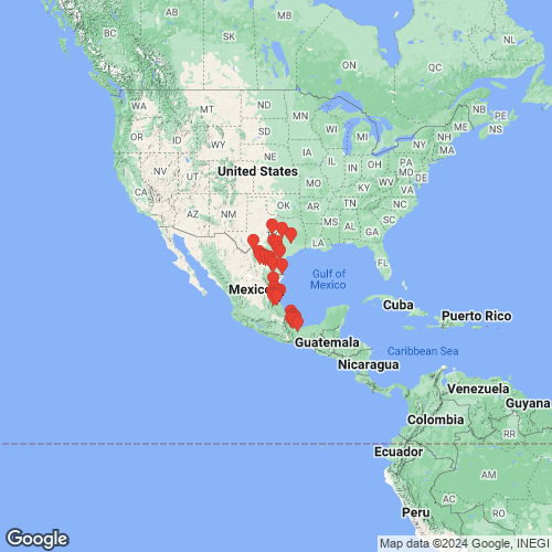
Range: Southern Texas to Honduras. Map of Georeferenced Specimens
 |
Honduras |

UMMZ_121213
Honduras. Dubious record.
|
|
|
Mexico |

SMF_12416
Rio Casas Viejas, 25 m n.v. Valles, Mexiko
|

BMNH_1874-12-11-2
Tampico and Tecamate, Mexico
|

SMF_12418
Tampico, Mexico
|

BMNH_1907-10-28-268
Mexico
|

NCSM_MFM_19084
Rio Jaltepec, Jesus Carranza, Veracruz, Mexico
|

INHS_21707
Rio Casas Viejas, N of Valles, San Luis Potosi, Mexico
|

INHS_21708
Rio Casas Viejas, N of Valles, San Luis Potosi, Mexico
|

INHS_21709
Rio Casas Viejas, N of Valles, San Luis Potosi, Mexico
|

FMNH_11642
Rio Papaloapan, El Hule, Veracruz, Mexico
|

FMNH_67943
Rio Casas Viejas, between Valles and Pujol, Mexico
|

ANSP_129940
Tecomate River, near Tlacotalpan, Mexico
|

AMS_126904
Mexico
|

MNHN_MP_1298
Rio Cosamaloapan, Vera Cruz, Mexique
|

USNM_1282378-79
Veracruz, Rio San Juan at Rt. Mex. 25 ca. 20.5 roadmiles S of Santiago Tuxtla (junction of Rt. Mex. 25 and Rt. Mex. 180), and ca. 16.2 roadmiles from junction of Rt. Mex. 25 and Rt. Mex. 145
|

USNM_1282336
Veracruz, Rio San Juan at Rt. Mex. 25 ca. 20.5 roadmiles S of Santiago Tuxtla (junction of Rt. Mex. 25 and Rt. Mex. 180), and ca. 16.2 roadmiles from junction of Rt. Mex. 25 and Rt. Mex. 145
|

AMS_10232
Rio Guayalejo, 19 mi ENE Ciudad Monte, Tamaulipas, Mexico
|

BMNH_1964143
Mexico
|

CM_61.2007
Mexico
|

USNM_1282337
Veracruz, Rio Papaloapan off Rt. Mex. 175 in Cosamaloapan
|

USNM_1282338
Veracruz, Rio Papaloapan off road from Ciudad Aleman to Tuxtepec; ca. 0.5 roadmiles by dirt road to river; dirt road entrance to Aleman-Tuxtepec road is ca. 2.4 roadmiles W of divergence of roads to Ciudad Aleman and Cosamaloapan
|

AMS_102113
Rio Saldado, Anahuac, Nueva Leon, Mexico
|

AMS_102100
canal, 20.5 mi WNW Anahuac, Nueva Leon, Mexico
|

CM_61.766
Mexico, Tamaulipas, Tampico
|

INHS_21710
Rio Panuco, Pujal, San Luis Potosi, Mexico
|

USNM_122379
Matamoras, Mexico
|

AMNH_29220
Tamaulipas
|

USNM_251830
Sabinas River, Mexico
|

AMNH_31034
Mexico
|

AMNH_29201
Tampico River
|

USNM_1282339
Veracruz, Rio Papaloapan off Rt. Mex. 175 ca. 7.8 roadmiles S of the town square of Tlacotalpan
|

USNM_1282327-28
Mexico: Coahuila. Rio Salado de Nadadores, 0.5 mi S Progresso on road to HW 57 [distance from HW 57 is 14.6 mi]
|

INHS_89422
Rio Tempoal, Tempoal, Veracruz, Mexico
|

INHS_31738
100 km W Ciudad Acuna, 0.5 to 10 km E 102nd Meridian, Coahuila, Mexico
|

USNM_1282340
Veracruz, Rio Tesechoacan at Tesechoacan, ca. 0.5 miles N of bridge of Rt. Mex. 145 (ca. 9.3 roadmiles W of junction of Rt. Mex. 145 and Rt. Mex. 25)
|

OSUM_22682
Rio Grande at Falcon Reservoir, Tamaulipas, Mexico
|

OSUM_28272
“River Tampico, Mexico”
|

OSUM_46821
Rio Tempoal, [off Mexican Route 105, 50 mi. SW of Tampico]
|

OSUM_46822
Rio Panuco [25 mi. WSW of Tampico]
|

BMNH_MP_423
Rio Nopalapa, Mexico
|

USNM_1282329-30
San Luis Potosi, Rio Moctezuma at Tanquian de Escobedo
|

NCSM_MFM_1358
Mexico
|

USNM_1282331-35
Tamaulipas, Rio Guayalejo at Rt. Mex. 80 near Mexcoltzin. ca. 17.9 roadmiles E of Ciudad Mante (measured from circle in southern Mante where the Tampico, Mante, and Valles roads diverge)
|

UF_215326
river, 14 km E Xilitla, San Luis Potosi, Mexico, 21° 26’ 13” N, 98° 56’ 00” W
|

INHS_89438
Rio Tampaón [22 km SSW of Ciudad Valles, 38 km S of Tamuin, 132 km WSW of Tampico], San Luis Potosi, Mexico
|

UMMZ_34890
Rio San Juan, nr Haciendo de Cuatotolapam, Mexico
|

INHS_89442
Rio Pánuco, 18 km WSW of Panuco, 55 km SW of Tampico [Oviedo], Tamaulipas, Mexico
|

USNM_84843
Tampico, Mexico
|

INHS_89430
Rio Purificacion, 27-28 km NE of Victoria, 235 km SW of Matamoros, Presa Vicente Guerrero, Tamaulipas, Mexico
|

UMMZ_31844
Rio San Juan, Mexico
|

NCSM_5812
Rio Tamesi, Hwy. 80, @16 km W Magiscatzin, Tamaulipas, Mexico
|

NCSM_5806
El Tempoal, El Higo, Veracruz, Mexico
|

USNM_1282341-42
Veracruz, Rio Tempoal (or Rio Calabazo) at Rt. Mex. 105 between Tempoal and Platon Sanchez. N21°25'00" W98°23'30" 8 Feb 82
|

USNM_85338
Tecomate River, near Tlacotalpan, [Vera Cruz State], Mexico.
|

USNM_251829
Camargo, Tamaulipas, Mexico
|

ZMB_MP_0479
Tampico
|

ZMB_MP_0470
N.W. Mexico
|

USNM_84427
Matamoras, Mexico
|

SMF_12419
Veracruz, Mexico
|
|
|
|
COMA_B.0910 Cosamaloapan, Veracruz, México
COMA_B.0977 Laguna de San Marcos, San Cristóbal, Veracruz, México
|
USA |

USNM_83932
Medina R., Texas
|

USNM_524061
Rio Grande Terrace, at Romina, Zapata Co., Texas
|
|
|
UTAP_5193 Medina River, Medina county, Texas, 0.5 mi. N of north edge of Castroville [along river road where low water bridge to Camp Cayoca crosses river, east from river road]
|
unknown |

ZMB_MP_0480
[no locality available - Central America]
|
|
|
Genbank Vouchers
USAUF_441144-007 (COI, 16S, ND1, 28S, ITS1, 5.8S) USA, Texas, Brown County, Colorado River downstream of Co. Rd. 229 (31.4831003, -99.0305955) UF_441145-008 (COI, ND1, 28S, ITS1, 5.8S) Navasota River, Brazos drainage (30.3547, -96.1416) NRI_8163_3 (COI, 16S) USA: Guadalupe River, Texas NRI_8163_7 (COI, 16S) USA: Guadalupe River, Texas NRI_8173_1 (COI, 16S) USA: Brazos River, Texas NRI_8163_6 (COI, 16S) USA: Guadalupe River, Texas UAUC_314 (ND1, ITS1) Nueces River, Lake Corpus Christi, Live Oak Co. TX NRI_8163_4 (COI, 16S) USA: Guadalupe River, Texas NRI_8208_1 (COI) USA: Brazos River, Texas NRI_8107_1 (COI) USA: Rio Grande, Texas NRI_8503_3 (COI) USA: Rio Grande, Texas UAUC_78 (16S) Leon River, Belton Reservoir, Bell Co. TX UF_439463 (16S) USA: Texas, Brazos River NRI_8163_1 (COI) USA: Guadalupe River, Texas NRI_8135_3 (COI) USA: Rio Grande, Texas UF_438559 (SRA) USA, Texas, Live Oak County, Choke Canyon Reservoir at boat ramp on west side of lake near dam (28.47405, -98.25166)
Mp_2667_H1019 (COI, COII) Mp_2667_H1019g (COI M-type, COII M-type) UAUC_316 (ITS1, 5.8S)
|