|
Unionoidea | Unionidae | Ambleminae | Quadrulini | Quadrulina | Pustulosa species Pustulosa succissa (Lea, 1852): specimens
4 nominal species as synonyms
Taxonomic History (since 2007)
Fusconaia succissa — Zhou et al. (2007), Graf & Cummings (2007), Cummings & Graf (2010), ITIS (2012), Szumowski et al. (2012)
Quadrula succissa — Williams et al. (2008), Bogan (2010), IUCN (2011), Williams et al. (2011), Haag (2012), Williams et al. (2014)
Rotundaria succissa — Campbell & Lydeard (2012), Campbell & Lydeard (2012)
Amphinaias succissa — ITIS (2013)
Cyclonaias succissa — Williams et al. (2017), Johnson et al. (2018), Lopes-Lima et al. (2019), Graf & Cummings (2021), FMCS (2021), Hopper et al. (2023), Hauck et al. (2023)
Pustulosa succissa — Neemuchwala et al. (2023)
|
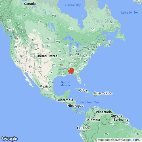
Range: Choctawhatchee, Yellow, and Escambia river drainages, eastern Gulf Coastal Plain in Alabama and Florida. Map of Georeferenced Specimens
 |
Genbank Vouchers
USAUF_438538 (QsucCho002) (COI, ND1, ITS1, 5.8S) USA, Florida, Walton/Washington County, Choctawhatchee River ~1.5 miles upstream of FL Hwy 20 bridge; sample taken in bend of river below mouth of slough on RDB (30.47335, -85.88662) UF_438538 (QsucCho003) (COI, ND1, ITS1, 5.8S) USA, Florida, Walton/Washington County, Choctawhatchee River ~1.5 miles upstream of FL Hwy 20 bridge; sample taken in bend of river below mouth of slough on RDB (30.47335, -85.88662) UF_441069 (QsucCho030) (COI, ND1, ITS1, 5.8S) USA, Alabama, Geneva County, Pea River at confluence of Choctawhatchee River in Geneva (31.02185, -85.85833) UF_438093 (QsucYel017) (COI, ND1, ITS1, 5.8S) USA, Alabama, Covington County, Yellow River on Co. Rt 97 @ 3 air miles S of Babbie (31.2385, -86.3401) UF_441240 (QsucCho039) (COI, ND1, ITS1, 5.8S) USA, Florida, Walton County, Bruce Creek on Walton Bridge Road, about 14 km (air) SSW of Ponce de Leon (30.61419, -86.01275) UF_438093 (QsucYel019) (COI, ND1, ITS1, 5.8S) USA, Alabama, Covington County, Yellow River on Co. Rt 97 @ 3 air miles S of Babbie (31.2385, -86.3401) UF_441240 (QsucCho033) (COI, ND1, ITS1, 5.8S) USA, Florida, Walton County, Bruce Creek on Walton Bridge Road, about 14 km (air) SSW of Ponce de Leon (30.61419, -86.01275) UF_438538 (QsucCho001) (COI, ND1, ITS1, 5.8S) USA, Florida, Walton/Washington County, Choctawhatchee River ~1.5 miles upstream of FL Hwy 20 bridge; sample taken in bend of river below mouth of slough on RDB (30.47335, -85.88662) UF_438093 (QsucYel018) (COI, ND1, ITS1, 5.8S) USA, Alabama, Covington County, Yellow River on Co. Rt 97 @ 3 air miles S of Babbie (31.2385, -86.3401) UF_438538 (QsucCho004) (COI, ND1, ITS1, 5.8S) USA, Florida, Walton/Washington County, Choctawhatchee River ~1.5 miles upstream of FL Hwy 20 bridge; sample taken in bend of river below mouth of slough on RDB (30.47335, -85.88662) UF_441069 (QsucCho032) (COI, ND1, ITS1, 5.8S) USA, Alabama, Geneva County, Pea River at confluence of Choctawhatchee River in Geneva (31.02185, -85.85833) UF_441240 (QsucCho034) (COI, ND1, ITS1, 5.8S) USA, Florida, Walton County, Bruce Creek on Walton Bridge Road, about 14 km (air) SSW of Ponce de Leon (30.61419, -86.01275) UF_438704 (QsucEsc021) (COI, ND1, ITS1, 5.8S) USA, Alabama, Crenshaw County, Patsaliga Creek on Co. Rt 59 just South of Patsburg (31.78132, -86.2247) UF_438368 (QsucEsc013) (COI, ND1, ITS1, 5.8S) USA, Florida, Escambia County, Escambia River at Molino in the fairground park and boat ramp (30.72339, -87.30584) UAUC_1456 (COI, 16S, ND1) Conecuh R., Pike Co., Alabama UF_441069 (QsucCho028) (COI, ND1) USA, Alabama, Geneva County, Pea River at confluence of Choctawhatchee River in Geneva (31.02185, -85.85833) UF_438704 (QsucEsc022) (COI, ND1) USA, Alabama, Crenshaw County, Patsaliga Creek on Co. Rt 59 just South of Patsburg (31.78132, -86.2247) UF_438871 (QsucCho027) (COI, ND1) USA, Alabama, Dale County, West Fork Choctawhatchee River on Dale Co. Rt 83 @ 5 air mi. SSE of Echo (31.4107, -85.53544) UF_441069 (QsucCho029) (COI, ND1) USA, Alabama, Geneva County, Pea River at confluence of Choctawhatchee River in Geneva (31.02185, -85.85833) UAUC_911-918 (COI, 16S) Conecuh River, Bscambia Drainage, Alabama UF_441069 (QsucCho031) (COI, ND1) USA, Alabama, Geneva County, Pea River at confluence of Choctawhatchee River in Geneva (31.02185, -85.85833) UAUC_525-528 (COI, 16S) Pea R., Geneva Co., Alabama UAUC_525 (ND1) Pea R., Geneva Co., Alabama UF_438538 (SRA) USA, Florida, Walton/Washington County, Choctawhatchee River ~1.5 miles upstream of FL Hwy 20 bridge; sample taken in bend of river below mouth of slough on RDB (30.47335, -85.88662)
|

