|
Unionoida | Unionoidea | Unionidae | Parreysiinae | Lamellidentini | Lamellidens species Lamellidens jenkinsianus (Benson, 1862): specimens
3 nominal species as synonyms
Taxonomic History (since 2007)
Lamellidens jenkinsianus — Graf & Cummings (2007), Ramakrishna & Dey (2007), IUCN (2010), Bogan (2010), Gittenberger et al. (2018), Zieritz et al. (2018), Graf & Cummings (2021), Bolotov et al. (2022)
Lamellidens jenkinsianus jenkinsianus — Nesemann et al. (2007)
Lamellidens jenkinsianus sub sp. daccaensis — Ramakrishna & Dey (2007)
Lamellidens jenkinsianus daccaensis — Nesemann et al. (2007), IUCN (2011)
Parreysia daccaensis — Bogan (2010)
Lamellidens cf. jenkinsianus — Bolotov et al. (2017), Huang et al. (2019)
Lamellidens marginalis — Bolotov et al. (2017)
Lamellidens (marginalis-group) jenkinsianus — Bolotov et al. (2022), Bolotov et al. (2024)
|
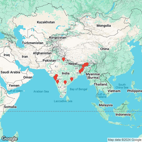
Range: Widespread in northeastern India, Bhutan, Nepal, Bangladesh, and Myanmar. Map of Georeferenced Specimens
 |
Genbank Vouchers
IndiaFBRC_ZSI_INV_4038 (L4-NKM-1 ) (COI, 16S, 28S) India: a pond, Sutar Gaon, Kamrup (Rural) District, Assam, Brahmaputra River drainage (26.45718193054, 91.7352294921) FBRC_ZSI_INV_4037 (L5-NKM-1 ) (COI, 16S) India: a pond, Sutar Gaon, Kamrup (Rural) District, Assam, Brahmaputra River drainage (26.45718193054, 91.7352294921) FBRC_ZSI_INV_4037 (LJ-NKM-2 ) (16S) India: a pond, Sutar Gaon, Kamrup (Rural) District, Assam, Brahmaputra River drainage (26.45718193054, 91.7352294921) NBFGR_LMK14 (COI) India: Dolwahal Right Canal, 18.46°N, 73.20°E, Ambā River basin, Maharashtra NBFGR_LMK25 (COI) India: Dolwahal Right Canal, 18.46°N, 73.20°E, Ambā River basin, Maharashtra NBFGR_LMN34 (COI) India: 29.37°N, 78.20°E, Ganges River basin, Uttar Pradesh Mp_3764_SBM28 (COI) India: Maharashtra FBRC_ZSI_1138 (RLd1) (COI) India: Krishna River, 16.36°N, 79.17°E, Nagarjuna Sagar, Telangana FBRC_ZSI_1138 (RLd2) (COI) India: Krishna River, 16.36°N, 79.17°E, Nagarjuna Sagar, Telangana Mp_3764_SBM5 (COI) India: Maharashtra FBRC_ZSI_1138 (RLd3) (COI) India: Godavari River, 20.04°N, 73.68°E, Nashik, Maharashtra Mp_3764_SBM10 (COI) India: Maharashtra Mp_4239_Moll749 (COI) India: Panchaganga River, 16.681°N, 74.395°E, Krishna River basin, Maharashtra Mp_3764_SBM17 (COI) India: Maharashtra Mp_4369_SBM20 (COI) India: Maharashtra Mp_3764_SBM4 (COI) India: Maharashtra FBRC_ZSI_INV1945i (COI) India: Thatipudi Reservoir, 18.1780°N, 83.2019°E, Gosthani River basin, Andhra Pradesh Mp_3761_SBM8 (COI) India: Maharashtra NBFGR_LMK15 (COI) India: Dolwahal Right Canal, 18.46°N, 73.20°E, Ambā River basin, Maharashtra FBRC_ZSI_INV1945 (COI) India: Thatipudi Reservoir, 18.1780°N, 83.2019°E, Gosthani River basin, Andhra Pradesh CIFEFGB_LM1 (mtGenome) India: Damring River, approx. 25.5°N, 90.5°E, Garro Hills, Meghalaya
|